Difference between revisions of "2024-04-26 41 -88"
From Geohashing
Haberdasher (talk | contribs) (→Location) |
Haberdasher (talk | contribs) (→Photos) |
||
| Line 22: | Line 22: | ||
Image:2024-04-26_41_-88Hashspot.jpg | Picture of the area around the hashpoint | Image:2024-04-26_41_-88Hashspot.jpg | Picture of the area around the hashpoint | ||
</gallery> | </gallery> | ||
| + | |||
| + | {{A Tale of Two Hashes challenge | ||
| + | | latitude = 41 | ||
| + | | longitude = -88 | ||
| + | | date = 2024-04-26 | ||
| + | | name = [[User:Haberdasher|Haberdasher]] | ||
| + | | place = Winthrop (Avenue) | ||
| + | | image = 2024-04-26_41_-88Hashspot.jpg | ||
| + | }} | ||
[[Category:Expeditions]] | [[Category:Expeditions]] | ||
Revision as of 23:54, 27 April 2024
| Fri 26 Apr 2024 in 41,-88: 41.9148587, -88.0607955 geohashing.info google osm bing/os kml crox |
Location
The edge of a corner lot near the intersection of Winthrop Avenue and Davine Drive, two small residential roads in suburban Glendale Heights.
Participants
Expedition
Success! Details to follow.
Photos
Geohash Droid showing I'm within accuracy distance

Selfie near/at the hashpoint
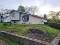
Picture of the area around the hashpoint


Haberdasher issued a challenge for the Tale of Two Hashes achievement
by geohashing in a place named Winthrop (Avenue) from the (41, -88) geohash on 2024-04-26.