2024-05-01 50 13
| Wed 1 May 2024 in 50,13: 50.9150652, 13.4317648 geohashing.info google osm bing/os kml crox |
Location
In a small piece of wood near the village Niederbobritzsch southwest of Dresden.
Participants
Plans
Take the train to Alternberg near the Czech border and cycle in a northwesterly direction past the hash to Tharandt. From there take the train back home.
Expedition
The weather was warm and sunny (20-26°C) with a strong southeasterly wind. After leaving the train in Altenberg I cycle southwards up to the ridge of the Ironore mountains and the Czech border. From there I mostly cycled towards the northwest with the wind blowing from behind to Niederbobritzsch where I took a small side path from the main road to access the hash. As I came closer it became clear, that access would be difficult as left of the path the terrain was falling steeply. At the closed point I managed to get as closes as about 10m to the hash without falling down.
This could have been my first successful geohashing expedition outside my home graticule. But still it was a great day out with nice sights and also a visit to 2 stations of the Königlich-Sächsische Triangulirung, the topographical survey of Saxony that was undertaken in the second half of the 19th century.
Tracklog
See activity on Strava
Photos

Screenshot of near the hash
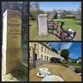
the 2 land survey stations and a coffee


Achievements
--