Difference between revisions of "2024-05-01 51 4"
Blauwe BIC (talk | contribs) (Initial creation) |
Blauwe BIC (talk | contribs) (Removed unjust category) |
||
| (3 intermediate revisions by 2 users not shown) | |||
| Line 13: | Line 13: | ||
}}<!-- edit as necessary --> | }}<!-- edit as necessary --> | ||
== Location == | == Location == | ||
| − | + | The hash was located in the city of Rotterdam, on a public square (Piet Paaltjensplein) in the medium-density residential district Spangen. | |
== Participants == | == Participants == | ||
| − | + | [[User:Blauwe BIC|Blauwe BIC]] ([[User talk:Blauwe BIC|talk]]) | |
| − | |||
== Plans == | == Plans == | ||
| − | + | Beautiful day, lovely weather, easily accessible hash, close to home: excellent conditions for a nice and easy bicycle ride. | |
== Expedition == | == Expedition == | ||
| − | + | Leaving home at around 5 PM, it was rush hour so there was a lot of traffic. No major hiccups, though, so after about half an hour cycling, I arrived at the identified square. | |
| + | |||
| + | Before leaving, I only checked the OpenStreetMap view of the situation without looking at any satellite imaging. I expected the square to be free of obstacles, but upon arrival I stumbled across some fenced off shrubberies. After checking the satellite, I determined that the hash was located outside the fenced off areas, so it was accessible. | ||
| + | |||
| + | A lovely historical landmark right on the north side of the square is the Justus van Effencomplex. A social housing project from 1922, the complex was revolutionary in the use of internal logistics, elevated walkways and some centralised facilities. More about that [https://en.wikipedia.org/wiki/Michiel_Brinkman here on Wikipedia] if you're interested. | ||
| + | |||
| + | On the way there, I passed through a street where cars an bicycles were mixed, which was annoying during rush hour. So I decided to head back home via a different route. It was only afterwards that I realised I would have gotten the Tron achievement that way, if only I kept a GPS log from the start. Oh well. | ||
== Tracklog == | == Tracklog == | ||
| − | + | No tracklog available. | |
== Photos == | == Photos == | ||
| − | < | + | <gallery> |
| − | Image: | + | Image:2024-05-01 51 4 Bike ride.jpg | Riding my bicycle through Rotterdam |
| − | -- | + | Image:2024-05-01 51 4 GPS.png | GPS proof of location |
| − | + | Image:2024-05-01 51 4 Shrubberies.jpg | Nooo, not another shrubbery! | |
| + | Image:2024-05-01 51 4 Justus van Effencomplex.jpg | The Justus van Effencomplex is a semi-gated community today | ||
| + | Image:2024-05-01 51 4 Delfshaven.jpg | A view of the Delfshaven district I passed on the way home | ||
</gallery> | </gallery> | ||
== Achievements == | == Achievements == | ||
{{#vardefine:ribbonwidth|100%}} | {{#vardefine:ribbonwidth|100%}} | ||
| − | + | {{Minesweeper geohash | |
| − | + | | graticule = Utrecht, Netherlands | |
| − | + | | ranknumber = 3 | |
| − | + | | e = true if graticule to the east has been hashed (optional) | |
| − | + | | sw = true if graticule to the southwest has been hashed (optional) | |
| + | | w = true if graticule to the west has been hashed (optional) | ||
| + | | name = Blauwe BIC | ||
| + | }} | ||
| − | + | {{bicycle geohash | |
| − | + | | latitude = 51 | |
| − | + | | longitude = 4 | |
| − | + | | date = 2024-05-01 | |
| − | + | | name = Blauwe BIC | |
| + | | distance = 5 kilometers | ||
| + | | bothways = true | ||
| + | }} | ||
| − | + | __NOTOC__ | |
| − | |||
| − | |||
[[Category:Expeditions]] | [[Category:Expeditions]] | ||
| − | |||
[[Category:Expeditions with photos]] | [[Category:Expeditions with photos]] | ||
| − | |||
| − | |||
| − | |||
| − | |||
| − | |||
[[Category:Coordinates reached]] | [[Category:Coordinates reached]] | ||
| − | + | {{location|NL|ZH}} | |
| − | |||
| − | |||
| − | |||
| − | |||
| − | |||
| − | |||
| − | |||
| − | |||
| − | |||
| − | |||
| − | |||
| − | |||
| − | |||
| − | |||
| − | |||
| − | |||
| − | |||
Latest revision as of 07:05, 2 May 2024
| Wed 1 May 2024 in 51,4: 51.9150652, 4.4317648 geohashing.info google osm bing/os kml crox |
Location
The hash was located in the city of Rotterdam, on a public square (Piet Paaltjensplein) in the medium-density residential district Spangen.
Participants
Plans
Beautiful day, lovely weather, easily accessible hash, close to home: excellent conditions for a nice and easy bicycle ride.
Expedition
Leaving home at around 5 PM, it was rush hour so there was a lot of traffic. No major hiccups, though, so after about half an hour cycling, I arrived at the identified square.
Before leaving, I only checked the OpenStreetMap view of the situation without looking at any satellite imaging. I expected the square to be free of obstacles, but upon arrival I stumbled across some fenced off shrubberies. After checking the satellite, I determined that the hash was located outside the fenced off areas, so it was accessible.
A lovely historical landmark right on the north side of the square is the Justus van Effencomplex. A social housing project from 1922, the complex was revolutionary in the use of internal logistics, elevated walkways and some centralised facilities. More about that here on Wikipedia if you're interested.
On the way there, I passed through a street where cars an bicycles were mixed, which was annoying during rush hour. So I decided to head back home via a different route. It was only afterwards that I realised I would have gotten the Tron achievement that way, if only I kept a GPS log from the start. Oh well.
Tracklog
No tracklog available.
Photos
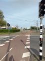
Riding my bicycle through Rotterdam
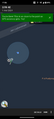
GPS proof of location
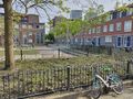
Nooo, not another shrubbery!
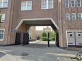
The Justus van Effencomplex is a semi-gated community today
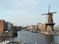
A view of the Delfshaven district I passed on the way home


Achievements
Blauwe BIC achieved level 3 of the Minesweeper Geohash achievement
|
Blauwe BIC earned the Bicycle geohash achievement
|