Difference between revisions of "2024-05-01 59 10"
(→Photos) |
|||
| Line 13: | Line 13: | ||
Because the centre is quite far out of the city in the opposite direction of the hash, we got to take the number 3 metro for almost its entire length (barring 3 stops), followed by a nice countryside bus. | Because the centre is quite far out of the city in the opposite direction of the hash, we got to take the number 3 metro for almost its entire length (barring 3 stops), followed by a nice countryside bus. | ||
| − | My pre-planned Komoot route then took us straigh up a hill and into the woods, altogether around 2.5km each way and around 200m of elevation. All of this in the best weather we've had since I arrived in Oslo by the way, sunny and | + | My pre-planned Komoot route then took us straigh up a hill and into the woods, altogether around 2.5km each way and around 200m of elevation. All of this in the best weather we've had since I arrived in Oslo by the way, sunny and 20°C. We were a bit tired from the climbing earlier but made it through some nice hiking trails, past a nice big anthill, through a pasture (with no cows in sight) and finally to the patch of grass with the geohash on it. After some brief questioning if it was public or not, we decided to go for it since there was no fence, plus it was just about 2 meters off a public path, and quite far from the next building. |
==Tracklog== | ==Tracklog== | ||
Revision as of 19:20, 1 May 2024
| Wed 1 May 2024 in 59,10: 59.9150652, 10.4317648 geohashing.info google osm bing/os kml crox |
Location
This geohash is located on a field in Bærum.
Participants
Expedition
Since it's a public holiday, we started our day by going to the Climbing Centre at the east of Oslo, and headed off towards Bærum in the early afternoon. I say "we" because I managed to drag along my lovely fiancé.
Because the centre is quite far out of the city in the opposite direction of the hash, we got to take the number 3 metro for almost its entire length (barring 3 stops), followed by a nice countryside bus.
My pre-planned Komoot route then took us straigh up a hill and into the woods, altogether around 2.5km each way and around 200m of elevation. All of this in the best weather we've had since I arrived in Oslo by the way, sunny and 20°C. We were a bit tired from the climbing earlier but made it through some nice hiking trails, past a nice big anthill, through a pasture (with no cows in sight) and finally to the patch of grass with the geohash on it. After some brief questioning if it was public or not, we decided to go for it since there was no fence, plus it was just about 2 meters off a public path, and quite far from the next building.
Tracklog
Photos
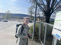
My drag-alongee in high spirits at the bus stop in Bærum
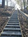
A set of stairs to start the hike
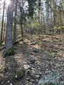
A little incline in the woods
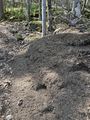
The mentioned ant hill
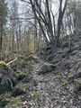
More woods
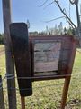
Sign with hiking paths
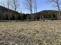
The lovely vista at the hash

Selfie #1

"Take the one where I look angry, that way it gives more credit for the drag-along achievement."


Achievements
TBD