Difference between revisions of "Cambridge, United Kingdom"
From Geohashing
imported>Youpi |
(→Local Geohashers) |
||
| Line 26: | Line 26: | ||
Mmm, it looks like there is a mistake above: it is *not* in the (52,0) graticule... | Mmm, it looks like there is a mistake above: it is *not* in the (52,0) graticule... | ||
| + | :True, but the (52,0) location is further from Cambridge, and significantly more underwater. | ||
[[Category:British Isles]] | [[Category:British Isles]] | ||
Revision as of 14:43, 25 May 2008
| - | - | - |
| Northampton | Cambridge | - |
| London West | London East | - |
[[Category:Meetup in {{{lat}}} {{{lon}}}| ]]
This graticule has boundaries from 52° to 53° latitude, and 0° to 1° longitude and contains Cambridge, UK. The graticle from -1° to 0° longitude is also near to Cambridge, but, due to the symmetry about the prime meridian, will never provide locations closer to the centre of Cambridge.
Local Geohashers
- Slainveteran is bike powered, so will only be able to make it when the coordinates lie nearby Cambridge itself
- lilac is also bike powered, but might be prepared to cycle up to about ten miles for a Saturday location.
- Spanky is also bike powered, and going this afternoon (Saturday, 24/5) from Cambridge.
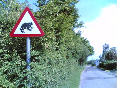
- youpi is bike powered, was there (52.126648°, 0.547533°) this afternoon (Saturday, 24/5) between 16:00 and 16:30 but saw nobody :/ Anyway it was a cool 46 miles tour! On the way I spotted an unexpected road sign:
For the cycle-powered, Sunday's location (2008-05-25) looks to be reachable from Bishops Stortford / Stansted Airport railway stations (though it's about 10 miles each way):
51.9417748528,0.18287359767
Mmm, it looks like there is a mistake above: it is *not* in the (52,0) graticule...
- True, but the (52,0) location is further from Cambridge, and significantly more underwater.
