Difference between revisions of "File:20080607den-proof.png"
From Geohashing
(Maintenance script uploaded File:20080607den-proof.png) |
m (Replacing Category:GPS receivers with Category:GNSS receivers) |
||
| Line 1: | Line 1: | ||
I couldn't remember how to make the mac take a screen shot at the time, but luckily the next time i opened it, it had saved the screen with the last coordinates, so i was able to figure it out later at home. we were more or less on the point, actual coordinates were supposed to be 40.501784°, -105.114371° | I couldn't remember how to make the mac take a screen shot at the time, but luckily the next time i opened it, it had saved the screen with the last coordinates, so i was able to figure it out later at home. we were more or less on the point, actual coordinates were supposed to be 40.501784°, -105.114371° | ||
| − | [[Category:Meetup on 2008-06-07]][[Category:Meetup in 40 -105]][[Category: | + | [[Category:Meetup on 2008-06-07]][[Category:Meetup in 40 -105]][[Category:GNSS receivers]] |
Latest revision as of 18:17, 21 September 2020
I couldn't remember how to make the mac take a screen shot at the time, but luckily the next time i opened it, it had saved the screen with the last coordinates, so i was able to figure it out later at home. we were more or less on the point, actual coordinates were supposed to be 40.501784°, -105.114371°
File history
Click on a date/time to view the file as it appeared at that time.
| Date/Time | Thumbnail | Dimensions | User | Comment | |
|---|---|---|---|---|---|
| current | 15:27, 30 January 2020 | 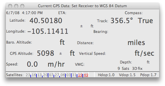 | 570 × 298 (56 KB) | Maintenance script (talk | contribs) |
- You cannot overwrite this file.
File usage
The following 2 pages link to this file: