Difference between revisions of "Tauranga, New Zealand"
From Geohashing
(→Photo Gallery) |
imported>Greenslime (→Sucessful Geohashes) |
||
| Line 20: | Line 20: | ||
==Sucessful Geohashes== | ==Sucessful Geohashes== | ||
| − | none as yet | + | none as yet, virginity still up for grabs! And most easterly hash! |
==Failed Geohashes== | ==Failed Geohashes== | ||
Revision as of 23:12, 20 June 2010
| Coromandel | The Alderman Islands | -36,177 |
| Hamilton | Tauranga | Waiorore |
| South Waikato | Rotorua | Opotiki |
|
Today's location: geohashing.info google osm bing/os kml crox | ||
Today's Location: Tauranga, NZ
The Tauranga graticule is located at latitude -37, longitude 176.
Sucessful Geohashes
none as yet, virginity still up for grabs! And most easterly hash!
Failed Geohashes
![]() 2010-06-07 - Forestry Area, Omanawa Road, Omanawa Falls, Tauranga
2010-06-07 - Forestry Area, Omanawa Road, Omanawa Falls, Tauranga
Photo Gallery
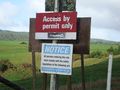
'Permit required' and 'No Trespassing' signs sighted prior to this one changed our minds about this hash

Locals
None.