imported>Keijoran |
imported>Steingesicht |
| (5 intermediate revisions by 5 users not shown) |
| Line 1: |
Line 1: |
| − | | + | {{ GalleryItem | File:2013_04_07_51_-0_geohashno.jpg | London West, United Kingdom | 2013-04-07 51 -0 }} |
| − | <!-- If you did not specify these parameters in the template, please substitute appropriate values for IMAGE, LAT, LON, and DATE (YYYY-MM-DD format)
| + | {{ GalleryItem | File:2013-04-07_52_6_grin.jpg | Zwolle, Netherlands | 2013-04-07 52 6 }} |
| − | | + | {{ GalleryItem | File:2013-04-07_40_-77_Upstream_low_res.gif | State Collage, Pa, United States | 2013-04-07 40 -77 }} |
| − | [[Image:{{{image|IMAGE}}}|thumb|left]]
| + | {{ GalleryItem | File:2013-04-07_63_28_nilsiä2_1500px.jpg | Nilsiä, Finland | 2013-04-07 63 28 }} |
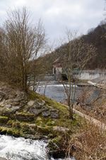
| − | | + | {{ GalleryItem | File:2013 04 07 48 9 weir-nmz.jpg | Tübingen-Lustnau. Germany | 2013-04-07 48 9 }} |
| − | Remove this section if you don't want an image at the top (left) of your report. You should remove the "Image:" or "File:"
| |
| − | tag from your image file name, and replace the all upper-case word IMAGE in the above line.
| |
| − | | |
| − | And DON'T FORGET to add your expedition and the best photo you took to the gallery on the Main Page! We'd love to read your report, but that means we first have to discover it! :)
| |
| − | --> | |
| − | {{meetup graticule | |
| − | | lat=60 | |
| − | | lon=25 | |
| − | | date=2013-04-07 | |
| − | }} | |
| − | | |
| − | <!-- edit as necessary -->
| |
| − | __NOTOC__
| |
| − | == Location ==
| |
| − | <!-- where you've surveyed the hash to be -->
| |
| − | In Tuusula Kellokoski a few meters off of Toimelantie, near intersection of Pränninkuja.
| |
| − | | |
| − | == Participants ==
| |
| − | <!-- who attended: If you link to your wiki user name in this section, your expedition will be picked up by the various statistics generated for geohashing. You may use three tildes ~ as a shortcut to automatically insert the user signature of the account you are editing with.
| |
| − | -->
| |
| − | [[User:Keijoran|Keijoran]] and perhaps wife will try to get as close as possible to the actual hash point
| |
| − | | |
| − | == Plans ==
| |
| − | <!-- what were the original plans -->
| |
| − | I'll try to reach my first hash finally. Couple of times it was so near at yet so far. But maybe this time.
| |
| − | == Expedition ==
| |
| − | <!-- how it all turned out. your narrative goes here. -->
| |
| − | | |
| − | == Tracklog ==
| |
| − | <!-- if your GPS device keeps a log, you may post a link here -->
| |
| − | | |
| − | == Photos ==
| |
| − | <!-- Insert pictures between the gallery tags using the following format:
| |
| − | Image:2012-##-## ## ## Alpha.jpg | Witty Comment
| |
| − | --> | |
| − | <gallery perrow="5">
| |
| − | </gallery>
| |
| − | | |
| − | == Achievements ==
| |
| − | {{#vardefine:ribbonwidth|800px}} | |
| − | <!-- Add any achievement ribbons you earned below, or remove this section -->
| |
| − | | |
| − | | |
| − | <!-- =============== USEFUL CATEGORIES FOLLOW ================
| |
| − | Delete the next line ONLY if you have chosen the appropriate categories below. If you are unsure, don't worry. People will read your report and help you with the classification. -->
| |
| − | [[Category:New report]]
| |
| − | | |
| − | <!-- Potential categories. Please include all the ones appropriate to your expedition -->
| |
| − | <!-- If this is a planning page:
| |
| − | [[Category:Expedition planning]]
| |
| − | -->
| |
| − | | |
| − | <!-- An actual expedition:
| |
| − | [[Category:Expeditions]]
| |
| − | -- and one or more of --
| |
| − | [[Category:Expeditions with photos]]
| |
| − | [[Category:Expeditions with videos]]
| |
| − | [[Category:Expedition without GPS]]
| |
| − | -->
| |
| − |
| |
| − | <!-- if you reached your coords:
| |
| − | [[Category:Coordinates reached]]
| |
| − | | |
| − | | |
| − | --><!-- or if you failed :(
| |
| − | [[Category:Coordinates not reached]]
| |
| − | -- and a reason --
| |
| − | When there is a natural obstacle between you and the target:
| |
| − | [[Category:Not reached - Mother Nature]]
| |
| − |
| |
| − | When there is a man-made obstacle between you and the target:
| |
| − | [[Category:Not reached - No public access]]
| |
| − | | |
| − | When you failed get your GPS, car, bike or such to work:
| |
| − | [[Category:Not reached - Technology]]
| |
| − |
| |
| − | When you went to an alternate location, or decided early on to abort the expedition:
| |
| − | [[Category:Not reached - Did not attempt]]
| |
| − | | |
| − | (Don't forget to delete this final close comment marker) -->
| |