Difference between pages "Template:Expedition Images2/2013-07-13" and "2013-07-13 39 -77"
From Geohashing
< Template:Expedition Images2(Difference between pages)
imported>Mcbaneg |
imported>Calamus m (Categorizing) |
||
| Line 1: | Line 1: | ||
| − | <!-- | + | |
| − | <!-- | + | <!-- If you did not specify these parameters in the template, please substitute appropriate values for IMAGE, LAT, LON, and DATE (YYYY-MM-DD format) |
| − | + | ||
| − | + | [[Image:{{{image|IMAGE}}}|thumb|left]] | |
| + | |||
| + | Remove this section if you don't want an image at the top (left) of your report. You should remove the "Image:" or "File:" | ||
| + | tag from your image file name, and replace the all upper-case word IMAGE in the above line. | ||
| + | |||
| + | And DON'T FORGET to add your expedition and the best photo you took to the gallery on the Main Page! We'd love to read your report, but that means we first have to discover it! :) | ||
| + | --> | ||
| + | {{meetup graticule | ||
| + | | lat=39 | ||
| + | | lon=-77 | ||
| + | | date=2013-07-13 | ||
| + | }} | ||
| + | |||
| + | <!-- edit as necessary --> | ||
| + | __NOTOC__ | ||
| + | == Location == | ||
| + | <!-- where you've surveyed the hash to be --> | ||
| + | On the banks of the Antietam River | ||
| + | |||
| + | == Participants == | ||
| + | <!-- who attended: If you link to your wiki user name in this section, your expedition will be picked up by the various statistics generated for geohashing. You may use three tildes ~ as a shortcut to automatically insert the user signature of the account you are editing with. | ||
| + | --> | ||
| + | |||
| + | == Plans == | ||
| + | <!-- what were the original plans --> | ||
| + | |||
| + | == Expedition == | ||
| + | <!-- how it all turned out. your narrative goes here. --> | ||
| + | |||
| + | |||
| + | *On our way! -- [[User:OfficeLinebacker|OfficeLinebacker]] ([[User talk:OfficeLinebacker|talk]]) [http://www.openstreetmap.org/?lat=39.08587727&lon=-77.17057427&zoom=16&layers=B000FTF @39.0859,-77.1706] 17:11, 13 July 2013 (EDT) | ||
| + | == Tracklog == | ||
| + | <!-- if your GPS device keeps a log, you may post a link here --> | ||
| + | |||
| + | == Photos == | ||
| + | <!-- Insert pictures between the gallery tags using the following format: | ||
| + | Image:2012-##-## ## ## Alpha.jpg | Witty Comment | ||
| + | --> | ||
| + | <gallery perrow="5"> | ||
| + | |||
| + | Image:2013-07-13_39_-77_18-15-05-453.jpg | Abandoned structure [http://www.openstreetmap.org/?lat=39.64764215&lon=-77.68775462&zoom=16&layers=B000FTF @39.6476,-77.6878] | ||
| + | |||
| + | Image:2013-07-13_39_-77_18-19-11-415.jpg | The car that brought us here | ||
| + | |||
| + | Image:2013-07-13_39_-77_18-19-45-784.jpg | The path and view down to the hashpoint | ||
| + | |||
| + | Image:2013-07-13_39_-77_18-22-24-960.jpg | | ||
| + | |||
| + | Image:2013-07-13_39_-77_18-22-35-242.jpg | | ||
| + | |||
| + | Image:2013-07-13_39_-77_18-23-08-166.jpg | Allison walking near the hash | ||
| + | |||
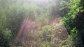
| + | Image:2013-07-13_39_-77_18-23-35-411.jpg | The vegetation is lush. | ||
| + | |||
| + | Image:2013-07-13_39_-77_18-25-08-645.jpg | The moss covered banks of Antietam Creek | ||
| + | |||
| + | Image:2013-07-13_39_-77_18-28-38-735.jpg | | ||
| + | |||
| + | Image:2013-07-13_39_-77_18-31-38-293.jpg | Silly us at the spot [http://www.openstreetmap.org/?lat=39.64644288&lon=-77.68793100&zoom=16&layers=B000FTF @39.6464,-77.6879] | ||
| + | </gallery> | ||
| + | |||
| + | == Achievements == | ||
| + | {{#vardefine:ribbonwidth|800px}} | ||
| + | <!-- Add any achievement ribbons you earned below, or remove this section --> | ||
| + | |||
| + | |||
| + | [[Category:Expeditions]] | ||
| + | [[Category:Expeditions with photos]] | ||
| + | [[Category:Coordinates reached]] | ||
Revision as of 06:59, 31 July 2013
| Sat 13 Jul 2013 in 39,-77: 39.6464569, -77.6879201 geohashing.info google osm bing/os kml crox |
Location
On the banks of the Antietam River
Participants
Plans
Expedition
- On our way! -- OfficeLinebacker (talk) @39.0859,-77.1706 17:11, 13 July 2013 (EDT)
Tracklog
Photos
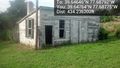
Abandoned structure @39.6476,-77.6878
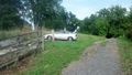
The car that brought us here
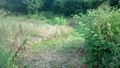
The path and view down to the hashpoint
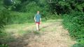
Allison walking near the hash
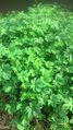
The vegetation is lush.
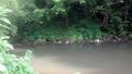
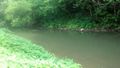
The moss covered banks of Antietam Creek
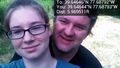
Silly us at the spot @39.6464,-77.6879


