Difference between revisions of "User:Birdray"
imported>Birdray |
m (per Renaming Proposal) |
||
| (3 intermediate revisions by one other user not shown) | |||
| Line 5: | Line 5: | ||
== Completed Expeditions == | == Completed Expeditions == | ||
| + | [[2013-05-11_35_-79]]<br> | ||
[[2013-03-02_36_-79]]<br> | [[2013-03-02_36_-79]]<br> | ||
[[2013-02-25_36_-80]]<br> | [[2013-02-25_36_-80]]<br> | ||
| Line 11: | Line 12: | ||
== Failed Expeditions == | == Failed Expeditions == | ||
| + | [[2013-03-10_36_-78]]<br> | ||
| + | [[2013-03-10_36_-79]]<br> | ||
[[2012-11-24_35_-79]] | [[2012-11-24_35_-79]] | ||
| Line 16: | Line 19: | ||
<gallery perrow="5"> | <gallery perrow="5"> | ||
| − | Image:2013-02-24_35_-79_01.jpg | Me in my trusty car having stopped just past the hashpoint (with some wild refraction c/o my window I guess) | + | Image:2013-05-11_35_-79_1.jpg | My general impression of the weather at the [[2013-05-11_35_-79]] hashpoint. |
| − | Image:2013-02-24_02.jpg | I was trying to get a shot of the exit sign for better proof of location, but it didn't come out clear enough | + | Image:2013-03-02_36_-79_1.jpg | The Oak Ridge town hall and post office, right across from the park where the [[2013-03-02_36_-79]] hashpoint. Welcome to the heart of Oak Ridge. |
| + | Image:2013-03-02_36_-79_2.jpg | And us in front of the Oak Ridge town hall and post office. | ||
| + | Image:2013-02-24_35_-79_01.jpg | Me in my trusty car having stopped just past the [[2013-02-24_35_-79]] hashpoint (with some wild refraction c/o my window I guess) | ||
| + | Image:2013-02-24_02.jpg | I was trying to get a shot of the exit sign for better proof of location at the [[2013-02-24_35_-79]] hashpoint, but it didn't come out clear enough | ||
Image:2012-11-24_35_-79b.jpg | Somewhere in this (blurry) field was the [[2012-11-24_35_-79]] hashpoint. | Image:2012-11-24_35_-79b.jpg | Somewhere in this (blurry) field was the [[2012-11-24_35_-79]] hashpoint. | ||
Image:2012-05-15_36_-80_1.jpg | Really nothing much to see here--a dark residential area at the [[2012-05-15_36_-80]] point--other than my absolutely rabid red-eye, which happens in almost every photo of me. | Image:2012-05-15_36_-80_1.jpg | Really nothing much to see here--a dark residential area at the [[2012-05-15_36_-80]] point--other than my absolutely rabid red-eye, which happens in almost every photo of me. | ||
| Line 39: | Line 45: | ||
| image = 2012-05-15_36_-80_1.jpg | | image = 2012-05-15_36_-80_1.jpg | ||
}} | }} | ||
| − | {{ | + | {{Graticule unlocked |
| latitude = 36 | | latitude = 36 | ||
| longitude = -80 | | longitude = -80 | ||
Latest revision as of 03:14, 20 March 2024
Contents
About Me
Bienvenid@s. I'm a Spanish teacher and all-around communication(s) nerd based in the 36,-80 graticule. I don't hash frequently as I'm more of a convenience hasher--I'm not able to travel far out of my way, so I'm constantly lurking in wait of a nearby hashpoint. If you're in the area, let me know! It's lonely hashing by yourself sometimes.
Planned Expeditions
Completed Expeditions
2013-05-11_35_-79
2013-03-02_36_-79
2013-02-25_36_-80
2013-02-24_35_-79
2012-05-15_36_-80
Failed Expeditions
2013-03-10_36_-78
2013-03-10_36_-79
2012-11-24_35_-79
(Some) Photos

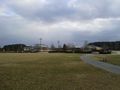
My general impression of the weather at the 2013-05-11_35_-79 hashpoint.
The Oak Ridge town hall and post office, right across from the park where the 2013-03-02_36_-79 hashpoint. Welcome to the heart of Oak Ridge.

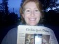
And us in front of the Oak Ridge town hall and post office.
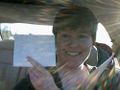
Me in my trusty car having stopped just past the 2013-02-24_35_-79 hashpoint (with some wild refraction c/o my window I guess)
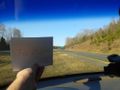
I was trying to get a shot of the exit sign for better proof of location at the 2013-02-24_35_-79 hashpoint, but it didn't come out clear enough
Somewhere in this (blurry) field was the 2012-11-24_35_-79 hashpoint.
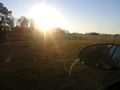
Really nothing much to see here--a dark residential area at the 2012-05-15_36_-80 point--other than my absolutely rabid red-eye, which happens in almost every photo of me.


Achievements
Birdray earned the Land geohash achievement
|
Birdray earned the Drag-along achievement
|
Birdray earned the Graticule Unlocked Achievement
|
Birdray earned the No trespassing consolation prize
|
Birdray earned the Prize poultry Consolation Prize
|
Birdray achieved level 1 of the Minesweeper Geohash achievement
|
Birdray earned the Consecutive geohash achievement
|
Birdray achieved level 2 of the Minesweeper Geohash achievement
|