Difference between revisions of "User:Mcbaneg"
imported>Jiml m (Removed redirect) |
imported>Mcbaneg |
||
| Line 1: | Line 1: | ||
| + | [[Image:{{{image|IMG_2478.jpeg}}}|thumb|left]] | ||
| + | <!-- If you did not specify these parameters in the template, please substitute appropriate values for IMAGE, LAT, LON, and DATE (YYYY-MM-DD format) | ||
| + | {{ GalleryItem | File:IMG_2478.jpeg| Carlisle, UK | 2013-05-11 54 -2 }} | ||
| + | |||
| + | Remove this section if you don't want an image at the top (left) of your report. You should remove the "Image:" or "File:" | ||
| + | tag from your image file name, and replace the all upper-case word IMAGE in the above line. | ||
| + | |||
| + | And DON'T FORGET to add your expedition and the best photo you took to the gallery on the Main Page! We'd love to read your report, but that means we first have to discover it! :) | ||
| + | --> | ||
| + | {{meetup graticule | ||
| + | | lat=54 | ||
| + | | lon=-2 | ||
| + | | date=2013-05-12 | ||
| + | }} | ||
| + | |||
| + | |||
| + | __NOTOC__ | ||
| + | == Location == | ||
| + | Heather moorland just off a rural road at the top of the ridge separating the Wear and Tees valleys, County Durham, UK. | ||
| + | |||
| + | == Participants == | ||
| + | |||
| + | * George McBane [[User:Mcbaneg|Mcbaneg]] | ||
| + | * Jake Muonio | ||
| + | * Katja McBane | ||
| + | * Rebekah McBane | ||
| + | |||
| + | |||
| + | == Expedition == | ||
| + | |||
| + | Two hashpoints in a row in the Durham Dales (my favorite bit of country here in NE England): yesterday in a creek valley, today on a high ridge, and both within less than an hours' drive. So we figured, consecutive hash time. | ||
| + | |||
| + | Today's hashpoint was only about forty feet off the road. Again, no GPS, and no useful smartphone location marker. But we | ||
| + | had an easy time finding the characteristic triangle-shaped section of vegetation (dark green moss, as it turns out) that showed up clearly on the satellite map. The ridge location was spectacular heather moor (as we expected from the location) but the visibility was marginal and the wind and light rain encouraged us not to linger too long. | ||
| + | |||
| + | |||
| + | == Photos == | ||
| + | |||
| + | <gallery perrow="2"> | ||
| + | |||
| + | Image:crosshillfarm_marked.jpg| | ||
| + | Image:nookton-1st-triangulation.jpg| | ||
| + | </gallery> | ||
| + | |||
| + | <gallery perrow="3"> | ||
| + | Image:IMG_2502.jpeg| | ||
| + | Image:IMG_2478.jpeg|We didn't meet any other geohashers but we did speak with some local residents. | ||
| + | </gallery> | ||
| + | |||
| + | == Achievements == | ||
| + | {{#vardefine:ribbonwidth|800px}} | ||
| + | <!-- Add any achievement ribbons you earned below, or remove this section --> | ||
| + | |||
| + | * Land Geohash | ||
| + | |||
| + | [[Category:Expeditions]] | ||
| + | [[Category:Expeditions with photos]] | ||
| + | [[Category:Expedition without GPS]] | ||
| + | [[Category:Coordinates reached]] | ||
Revision as of 23:25, 12 May 2013

| Sun 12 May 2013 in 54,-2: 54.6778850, -2.0141189 geohashing.info google osm bing/os kml crox |
Location
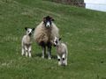
Heather moorland just off a rural road at the top of the ridge separating the Wear and Tees valleys, County Durham, UK.
Participants
- George McBane Mcbaneg
- Jake Muonio
- Katja McBane
- Rebekah McBane
Expedition
Two hashpoints in a row in the Durham Dales (my favorite bit of country here in NE England): yesterday in a creek valley, today on a high ridge, and both within less than an hours' drive. So we figured, consecutive hash time.
Today's hashpoint was only about forty feet off the road. Again, no GPS, and no useful smartphone location marker. But we had an easy time finding the characteristic triangle-shaped section of vegetation (dark green moss, as it turns out) that showed up clearly on the satellite map. The ridge location was spectacular heather moor (as we expected from the location) but the visibility was marginal and the wind and light rain encouraged us not to linger too long.
Photos


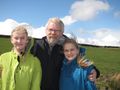
We didn't meet any other geohashers but we did speak with some local residents.

Achievements
- Land Geohash