Difference between revisions of "Wanganui, New Zealand"
imported>Greenslime m (add info) |
m (per Renaming Proposal) |
||
| (9 intermediate revisions by 5 users not shown) | |||
| Line 1: | Line 1: | ||
| − | + | [[File:-39 175 CentralPlateauNZ.jpg|centre|thumb|Central Plateau of the North Island of New Zealand.|1000px]] | |
| − | + | ||
{{QuickLinks|lat=-39|lon=175 | {{QuickLinks|lat=-39|lon=175 | ||
}} | }} | ||
| Line 19: | Line 19: | ||
}} | }} | ||
<!-- | <!-- | ||
| − | This graticule is located at [[-39,175]]. | + | This graticule is located at [[-39,175]]. {{Today's location|lat=-39|lon=175}} |
--> | --> | ||
==Description== | ==Description== | ||
| − | The Wanganui graticule | + | The Wanganui graticule includes the Tongariro National Park, which is the North Islands outdoor playground! The landscape is dominated by the three volcanoes - Mt Ruapehu, Mt Ngaruhoe and Mt Tongariro, and the surrounding tussock land. There are many outdoor activities to be had in the area including tramping, skiing, mountain biking, kayaking and kite-flying to name a few. There are also many fine multiday tramps around the Central Plateau volcanoes and the Kaimanawa Ranges to the east. The area is also famous for Waiouru Military Camp, which denys public access to a vast quantity of the harsh tussock land. The National Army Museum [http://www.armymuseum.co.nz/] is worth a look if your happen to be in the region. |
==Statistics== | ==Statistics== | ||
| − | {{ | + | {{Graticule unlocked |
| latitude = -39 | | latitude = -39 | ||
| longitude = 175 | | longitude = 175 | ||
| Line 46: | Line 46: | ||
==Geohashes Not Reached== | ==Geohashes Not Reached== | ||
| − | + | [[Image:Arrow4.png|8px]] [[2011-12-05 -39 175|2011-12-05]] - [[User:Greenslime|Greenslime]] - Bush, Erua | |
== Photos == | == Photos == | ||
<gallery perrow="5"> | <gallery perrow="5"> | ||
| + | File:2011-12-05 -39 175 171m That Way.jpg|Native Bush at Erua | ||
File:2011-07-04 -39 175 Welcome to Waiouru.jpg|Welcome to Waiouru, the desert oasis. | File:2011-07-04 -39 175 Welcome to Waiouru.jpg|Welcome to Waiouru, the desert oasis. | ||
File:2011-07-04 -39 175 View from the Hash.jpg|Sheep, as per normal | File:2011-07-04 -39 175 View from the Hash.jpg|Sheep, as per normal | ||
| Line 57: | Line 58: | ||
[[Category:New Zealand]] | [[Category:New Zealand]] | ||
| − | [[Category: | + | [[Category:Inactive graticules]] |
| − | [[Category: | + | [[Category:Unlocked graticules]] |
Latest revision as of 03:26, 20 March 2024

|
Latest Coordinates and Map Quick-Links | |
|---|---|
| Thursday 2024-05-09 | -39.7268575, 175.4290879 |
| Waitara | South Waikato | Rotorua |
| New Plymouth | Wanganui | Napier |
| Paraparaumu | Palmerston North | Waipukurau |
|
Today's location: geohashing.info google osm bing/os kml crox | ||
Contents
Description
The Wanganui graticule includes the Tongariro National Park, which is the North Islands outdoor playground! The landscape is dominated by the three volcanoes - Mt Ruapehu, Mt Ngaruhoe and Mt Tongariro, and the surrounding tussock land. There are many outdoor activities to be had in the area including tramping, skiing, mountain biking, kayaking and kite-flying to name a few. There are also many fine multiday tramps around the Central Plateau volcanoes and the Kaimanawa Ranges to the east. The area is also famous for Waiouru Military Camp, which denys public access to a vast quantity of the harsh tussock land. The National Army Museum [1] is worth a look if your happen to be in the region.
Statistics
Greenslime earned the Graticule Unlocked Achievement
|
Local Geohashers
none
Visitors
Geohashes Reached
![]() 2011-07-04 - Greenslime - Paddock, Waiouru
2011-07-04 - Greenslime - Paddock, Waiouru
Geohashes Not Reached
![]() 2011-12-05 - Greenslime - Bush, Erua
2011-12-05 - Greenslime - Bush, Erua
Photos
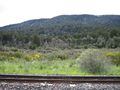
Native Bush at Erua
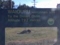
Welcome to Waiouru, the desert oasis.
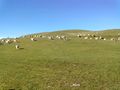
Sheep, as per normal
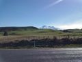
Mt Ruapehu


