2008-05-26 40 -111

I semi-successfully reached this point. My final position was within about 2000m of where the hash was, but I'd tried to hike in from Summit Park rather than Snyderville, which made reaching the point impossible from my angle. I got out of the car at the very peak of Matterhorn Drive, about five miles from the point according to my GPS. The road didn't continue at this point, but there was a well-marked, though muddy, trail that led in the direction of the point. Unfortunately, this was the Summit Peak trail, which is almost entirely switchbacks. Going five miles as the crow flies sounds a lot easier than it is when there's switchbacks involved. On the way, I found several abandoned and semi-abandoned buildings, which I took lots of pictures of (some of which are on my Flickr account). At about 9:30 I reached the hight of the marked trails. At this point, things started to go wrong. My watch broke, my camera strap broke, my camera's battery warning came on and the GPS started acting erratically and wouldn't point in a straight direction anymore. I left the trail and continued about a hundred meters past a water storage tank, which is when my camera's batteries died and the mountain became impossible to navigate. My GPS said my final position was 1450m from the point, but reviewing the satellite images, it might have been further away.
Pictures:

Taylor at his final position 1450m from the point.
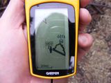
GPS showing Tsen's final location.


| Mon 26 May 2008 in Salt Lake City: 40.6731281, -111.6073080 geohashing.info google osm bing/os kml crox |
Tsen earned the Done with Nature consolation prize
|