2008-05-27 43 -2
| Tue 27 May 2008 in 43,-2: 43.1253672, -2.5771109 geohashing.info google osm bing/os kml crox |
The location was between Durango and Elorrio.
Unsuccessful attempt
Loggie: I met this lady on the bus on the way to Elorrio, and she told me that the hike I was going to do (with a side trip to the hash) was no good, and I should go up to the mountain above her house instead (well, perhaps tall hill is a more correct term). So I figured I'd go up the mountain aways, turn around, come back, and go to the hash. So she put me in her car, and drove me up to her house, and pointed me in the right direction (uphill). I climbed up, admired, came down, got lost in Elorrio, found my way again and started out. Only problem was that it started to pour, and me without any rain gear I wimped out and took the bus home.
However, I did get within 600 m of it, as that is the distance to the highway.
The lady was right, by the way, the view from the top was great, and I got to see sheep with cow-bells, which made a beautiful background noise for my hike.
I never even got a chance to use the pictures I'd taken of my computer screen in lieu of actually having a GPS or a map...
Pictures
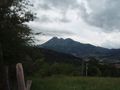
The view from where the lady sent me.

A sheep-one of the many animals I saw.

