2008-07-13 42 -123
| Sun 13 Jul 2008 in Grants Pass: 42.4962415, -123.2719690 geohashing.info google osm bing/os kml crox |
The hashpoint fell just north of Grants Pass, on Granite Hill Road. That and the coordinates were all the data I had. Robyn and Wade stopped for gas in Grants Pass and when a curious observer asked where we were headed I named Granite Hill Road. He not only gave us directions, but drew us a map, the image of which I'll attach to this entry when I'm using something more sophisticated than a Nokia Internet Device to connect.
After a few false starts finding said road (driver was mesmerised by the pointing arrow on the GPS receiver and refeused to heed turn directions that contradicted it) we were on our way. It was a nice twisty road that got narrower and narrower but stayed paid and we actually got to see the distance to target on the GPS fall to zero.
The road at this point was cut into a steep bank, so when I got off the bike to pinpoint the spot, the spot kept running away. I then realized that we had only acccuracy to 20 feet, and was 15 feet from the target. We picked a spot, backed up and "raced" throught it at what Wade declared was the maximum prudent speed for such a lane, in the absence of a posted speed limit. Our first speed hash.
I'm not going to take the achievement though because a) I forgot to record something showing the date and b) I think the actual hashpoint was not on the surface of the road.
I also forgot to leave a monument so that anyone that followed us (we came by at about 11 am) would know they had company.
- Almost Speedhash
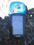
The GPS showing us almost there.
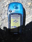
Accuracy is poorer than precision.
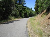
The view from the hashpoint.

Zipping through, seen over the driver's shoulder.


