2008-09-21 49 -124
| Sun 21 Sep 2008 in 49,-124: 49.2776262, -124.1564544 geohashing.info google osm bing/os kml crox |
Contents
[hide]Location
On a suburban road, 30 km north of Nanaimo.
Planning
While planning the Vancouver geohash of the same date we realized that the geohash in the next graticule over lay on an actual road. It was too doable to resist. More detailed planning discussion is on the talk page.
Participants
Expedition
The theme of this expedition was "If only tires were as hard to deflate as boats."'
From the beach to the ferry
The plan called for us to be off the beach after the first geohash of the day at 8 a.m., and, despite raft deflation delays, we were packed up, changed, had had a snack, and were ready to head to the Horseshoe Bay ferry at eight on the dot. Thepiguy followed Robyn to a church just off Davie Street where Robyn left her raft in the care off someone attending the service, and then we continued through town and through Stanley Park. We used the direct-through-the-causeway-on-the-sidewalk technique, rather than the thigh-busting scenic route used by cyclists who are merely training and not on important geohashing missions. We also bypassed the puzzlingly dead end routes pioneered by thepiguy and srs0 on two previous attempts to navigate the park.
Leaving the Lions Gate Bridge we followed the cycle route that bypasses the Capilano Bridge and emerges in a mall. Robyn drew on experience dating back to the 1970s and took a right turn leading to Taylor Way. Taylor Way, Robyn explained to thepiguy, is the reason cyclists from West Vancouver do not fear the Rocky Mountains. It goes up. We went up. I think maybe it wasn't as bad as I remembered, though, because our legs and lungs still functioned when we reached the Upper Levels Highway entrance ramp.
For a moment we thought we would have to go back down to the Marine Drive route, because at the top of the entrance ramp was a rectangular, white text-heavy sign that looked familiar. It is posted at the entrance to highways and wordily prohibits pedestrians, farm vehicles, horsedrawn vehicles, bicycles and all vehicles incapable of sustaining 60 km/h from continuing. "But bicycles can't be prohibited said thepiguy, "I see them there all the time. The weren't prohibited in the 1980s, possibly the last decade in which Robyn cycled to the Horseshoe Bay ferry, but Robyn has learned to expect change. And in this case there was change. As we approached the sign, it became evident that it was the prohibition sign, but it had been changed by the addition of a piece of official sign-coloured tape over the word "bicycles," the officialness of which was confirmed by other signs warning motorists to watch for bicycles on the road. We were good to go.
The Upper Levels highway generally has a good shoulder, and at each exit and entrance there is a signposted point instructing cyclists to Cross Here When Safe. "I hate those," says thepiguy, "It's never safe." It was generally safe for us, but there's a particular trick that some motorists pull. Approaching an exit ramp and seeing cyclists who have not yet crossed it they slow down to below the normal exit speed. I digress now for a short rant addressed to these motorists.
We the cyclists want you the motorist to get off the road down the exit road. The sooner you go by, the sooner we can cross behind you. We know how fast you are going. The ramp is designed for a high speed exit. Exit please. At high speed. We are not going to pull out in front of you while you are going 90 km/h, just go. If you slow down to forty-five, we have to wait for you. We may even have to stop to avoid actually taking the exit while waiting for you. The only thing you will have accomplished is closing the gaps between you and any subsequent traffic, so we have to wait until the vehicles behind you that you have impeded have also exited. Once you are gone, we will cross behind you.
We crossed many exit and entrance ramps We went up and down some small hills. We saw the signposted kilometres to the ferry drop steadily until the sign indicated the exit to be in 1200 metres. That 1200 metres consisted of about 500 metres of no-shoulder riding past a construction zone blocked off with curbs, 500 metres of obstacle course riding on a shoulder strewn with temporary signs urging motorists to get in the appropriate lane and read the signs. (Yes, there were signs telling people to read the signs), 500 metres of regular riding, another 300 metres across a bridge, then more around a corner and finally to a descending exit. I know that adds up to more than 1200 metres. It appears that the 1200 metre sign dated from before they blocked off the original exit and moved it west. That exit led to one of the greatest signs in cycling: Test Brakes Ahead. That means that you won't have to pedal for a while.
Almost as good as meeting other geohashers
We coasted all the way to the ferry toll booth and each paid $16.40 fare: $13.00 each for the people, $2.00 each for the bicycles, $1.25 fuel surcharge each, and a port tax. We took our tickets and went down our lane to the cyclist waiting area. The trip took us the planned hour and a half, to the minute. We're good! Our planning wasn't quite so meticulous for the next stage. Robyn determined that her turn-by-turn directions to the geohash had been on a piece of paper that was perhaps packed with the raft. Thepiguy had a printout of Google car directions, that followed a highway. Two other cyclists arrived in the waiting area so we asked them if highway 19A was a reasonable cycling route. "Where are you going?" they asked.
We started cagily, "About 30 km north of the ferry terminal, by Nanoose Bay."
They wanted to know more.
"Here," we showed them the Google maps printout.
"Oh, you're going to Garry Oaks?"
"Ah, yeah, that general area. It's on Fairwinds Drive."
"We live here," they showed us, about a 4 kilometre thumb width from the geohash. "Just follow us. We'll show you the good route to ride."
More conversation revealed that they had ridden across Canada all the way to St. John's, Newfoundland, and had just flown back to Vancouver yesterday. They were heading home for the first time in four months. Now that's a cycling expedition. They wanted to know more about ours.
There comes a point in a conversation between geohashers and non-geohashers where the former have side-stepped the questions for as long as they can and have to admit what they are doing. "We are going to a random point in the middle of Fairwinds Drive. It's a ... game." Seeing as we're in a fenced compound with the nearest exit being a ferry ramp leading straight into the sea, they don't flee. We agree to meet up and follow them off the ferry for the good route to Nanoose Bay.
Crossing the water
Once on the ferry we secured the bikes near the bow, and headed above decks for Robyn's third and thepiguy's first meal of the day. Waffles being unavailable on this sailing, we settled for chocolate milk, scrambled eggs, bacon, hash browns, and whole wheat toast plus a danish (thepiguy) and a thai chicken wrap (Robyn). We then walked around the ferry for a bit and thepiguy sat down to pretend to do his physics homework. Robyn pretended to help. She didn't know how to represent the electrostatic field on cavities a and b in a neutral conducting sphere, but neither did thepiguy, at least not with Robyn looking over his shoulder and asking what q was for. Meanwhile the weather outside had cleared from overcast to bright and sunny. This was going to be the best bicycle multihash ever. Except that it doesn't count as a bicycle multihash because we took the ferry.
From the ferry to the geohash and back
Cyclists and pedestrians exit the ferry first, to give them a fair headstart before they get run over by all the buses and commercial vehicles loaded right behind them. Our new friends led us around the corner and in towards town, which seemed to be the wrong direction, but I decided not to voice concerns that they were leading us to our doom. They had inspected our bicycles while we were waiting to load on the ferry, and found fault with each, so perhaps they didn't intend to mug us after all. And I was right: they only wanted to avoid a steep hill featured on the direct route.
The path they chose was a paved multiuse trail that followed the railroad tracks. Followed might be too generous a word here. While we navigated the path I pondered the possibility of creating a geohashing award for crossing a railway track in more than fifty different places in the course of the same geohashing expedition. Our new friends were heavily loaded with camping gear so the pace was moderate. I considered thanking them for the trail information and continuing on ahead, but then I reminded myself that it was a nice day, we weren't going to make the 3:15 ferry in any case, and we should just enjoy ourselves. As we stopped at a light waiting to cross a road, thepiguy mentioned casually that he had a flat tire now and needed to change it. One of our new friends insisted on changing it for him. I was kind of puzzled as to what we'd done to make us look like novice cyclists. Thepiguy had mentioned that the bike was only a month old, but the fact that he'd put over 2000 km on it already should have been a tip-off that he wasn't new at this. It's actually Robyn's fault that he got the flat, because it was only seconds before, Robyn had thought, "Hey, we got on and off the ferry with no flats." There is always dangerous debris on the ferry ramps and nearby roads, because the sea crossing shakes it loose from vehicles.
The tire was quickly changed, and we all set off again, still following the bike route. The tops of the hills were signed with the words STEEP HILL painted on the pavement, just a little too late to be useful for the beginning rollerblader. I can envision an amusing scene, with a rollerblader passing that sign, looking kind of like the coyote just after he steps off the edge of the cliff and just before he starts to plummet. And then it was Robyn's turn to get a flat. Robyn deserved one, riding on very old tires, and she pledged to get new ones before riding again. The same person insisted on changing that one too. I guess he just had strong fatherly instincts and liked the sense of satisfaction he got from fixing people's bicycles for them.
With no further flats we reached the turn-off that took us another way than them. They gave us a phone number so we could call them if we had any trouble and needed a ride. Nice people. Please help out some cyclists to help us pay them forward. We headed up a steep winding hill, watching the kilometres count down very slowly to the geohash. At one and a half kilometres from the geohash we were going up. At one kilometre away, we were going up. And then at six hundred metres from the geohash we crested the hill and realized that with a speed limit of 50 km/h we had an opportunity for the speed racer achievement. Heads down, heading down, gearing up with pedals going around, we zoomed down the hill, with Robyn reaching 56.9 km/h and thepiguy's cheap speedometer pegging at an even fifty. Speed Racer achieved! We turned the bikes around to find and mark the exact location.
The trouble with being in hilly countries is that there are hills. Thepiguy had a great theory about the satellites being closer and therefor easier to find, but we could track very few satellites and had precision of thirty to fifty 'metres. At one point our GPS receivers indicated the hashpoint 25 metres away in opposite directions. The zen of geohashing, however, is to sit quietly and wait for wildly roving hashpoints to come to you. This was effective and while standing in the ditch Robyn lured the geohash within 4 metres of her, about the distance from there to the middle of the road. At almost the same instant thepiguy got all the seconds on his receiver to match the published coordinates, so we celebrated success.
Success for any mission involving thepiguy mandates Nibs, and Robyn shared in this repast. We didn't have a proper game to play because Robyn couldn't fit Twister and a rubber raft on the bike at the same time, and neither of us wanted to risk getting our favourite card-based games wet in the forecast poor weather. We had to settle for celebratory picture taking, chalk-marking, GPS photographing and then the "see if we can catch the ferry" game. We felt a little guilty at ignoring the elaborate instructions we had been given for following the bike trails, but we used only a few of them, and mostly just got on the Island Highway and followed the signs to the ferry. We did get to go down the hill that the outbound route had spared us, and for that alone we are very grateful.
We reached the ferry with plenty of time to spare, and it was only as we leaned our bikes against the picnic table that the rain started. The weather forecast the night before had called for wet, cold and windy. We truly expected to be candidates for the drowned rat geohash. It was far better than expected. We had glorious blue skies through most of our Island travel and other than biking through one cloud along the Upper Levels (on the side of the North Shore mountains) we didn't get a drop of water until after we reached the ferry terminal for the return trip. There was a covered waiting area so we stayed dry while eating more food and waiting to board.
One last flat, and the long dark ride home
Once on board the ferry, you'd think the expedition was almost over, but there were still thirty to fifty kilometres to go, and after the ferry crossing there would only be about half an hour of daylight remaining. We looked at the ferry crossing as an hour and a half to rest up for the final stage of the journey. Thepiguy carefully secured Josephine to a railing to make sure that it wouldn't fall over as the ferry hit waves, and then he noticed. The rear tire, the same tire, was dead flat. We went upstairs, gorged ourselves once again on ferry food, and then came back to the vehicle deck to change the flat. Two broken plastic tire irons later thepiguy had a tube in, but the tube blew on inflation. Robyn has to admit to patching that one. Oops. Somehow thepiguy managed to get the tire off the rim, insert a tube he had patched, and get the tire and tube back on the rim again just in time for docking.
Robyn declared on the way over an intention to take a bike-rack-equipped bus back to Vancouver from the ferry terminal, but somehow thepiguy's quiet determination to not take the bus was sufficient, with no persuasion, to make her put on the bike lights and take to the road. Rounding the first corner on said road triggered a spontaneous and heartfelt exclamation from Robyn, addressed to some deity or other. The hill was infernal. But whichever deity it was heard and responded to her prayer, because she and thepiguy went up that hill and up and down many more all the way along the coast back to the Lions Gate Bridge without being hit by cars, getting any more flats, or having their legs replaced by jelly. After the Lions Gate the two parted ways for their individual most efficient routes home. The rain, and this was serious Vancouver rain, started for each only shortly before arriving home.
It was a brilliant, triumphant day.
Photographs
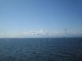
We pass another ferry during our ocean crossing.
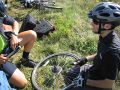
The first of three flats is repaired.
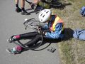
And then the second.
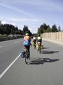
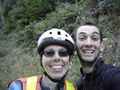
We had our own little biking party going on.
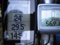
The bike computer displays the maximum speed achieved during our pass through the geohash.
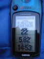
The obligatory GPS shot.
thepiguy's speedometer.
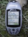
And thepiguy's GPS.
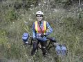
Robyn and T-Rex.
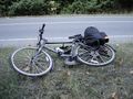
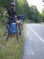
Josephine taking a rest.
It's a multihash!
Thepiguy holds Josephine and Успех while Robyn marks the geohash location with chalk.


