2008-10-07 54 -119
| Tue 7 Oct 2008 in 54,-119: 54.5568742, -119.4033689 geohashing.info google osm bing/os kml crox |
Contents
[hide]Participants
Just Robyn
Planning
After over a week of no geohashes in Grande Cache I was asked to go to Fort Nelson. The weather wasn't looking very good for the trip, but I don't mind a little rain if it affords an opportunity for a geohash. The Grande Cache airport is actually in the northwest corner of the Muskeg River graticule, but there was no chance of a geohash there. Today's coordinates are towards the centre of each graticule. I started the airplane, and while the engines were warming up I entered the coordinates for the geohash, selecting a lat long for Nose Creek, Alberta, one graticule northwest of my position. I knew I'd have to maneuver for weather, so there was no way to know in advance which if any geohashes would coincide with my route.
Expedition
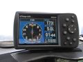
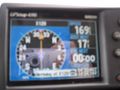
I took off and turned en route for my destination, a heading of 319 degrees. Once established, I checked what the heading would be to the geohash point: 315 degrees. That's too close not to try for. I altered course by the minuscule amount required to point at the geohash and held that line. I even swapped out one of the data fields on one page of the GPS so I could have course information and show lat-long position on the same screen. I forgot to show date, or photograph myself, but the date on the photo itself combined with my fingers reflected in the GPS should be sufficient for my claim to be accepted. I mean, come on: you know it's me! The proof photo is notable for the fact that I was within seventeen feet of the geohash as the shutter snapped--that's within the error of the instrument, and I hope that makes up for the poor focus of the image. To my eyes it reads: N54 33 24.7, W119 24 23.4. I've included another shot five miles back in clear focus, so you can see me closing on the point.
If you compare with the satellite image, you can see the road running through the little brown cleared patch; the geohash is in a patch just to the northeast of that.
After passing the point I reset my navigation GPS to the destination and then edited the values before the decimal on the X128 point, to see if I could get another geohash further northeast.
Photo Gallery
Approaching the point, I'm right on course.
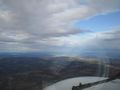
There it is, right off the nose.
And nailed it, passing overhead seventeen feet from the geohash.


