2008-10-16 68 17
| Thu 16 Oct 2008 in 68,17: 68.5291679, 17.5917478 geohashing.info google osm bing/os kml crox |
Hashing in the North
Guinness's first and Jeppzer's second expedition
Guinness found out about Geohashing yesterday and was trying to get someone to go to a new graticule; the point I chose was in the foreign country of Norway :-) 170km from Kiruna.
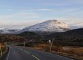
Around 2pm, right after work, we jumped in the car and were leaving our snowy town on our tour towards Norway, passing the country border without problems! We reached the Atlantic ocean after about 150km and the temperature was about +5 C but windy. We drove on for a while looking for a parking spot close to the hashpoint. We conveniently found one with only 900m to the hashpoint BUT it had 240m of elevation difference!
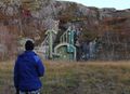
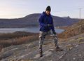
We crossed the road and went into the forest below the mountain to make our way through. At the foot of the mountain we found a fenced-in door that probably led inside the hill. On the right hand side of the fence we saw something that reminded us of a trail, or at least it was a climbable part of the hill. As we made our way higher and higher we realized the terrain was terrible, up up up, with only small trees tortured by the wind. After a little while the terrain went from moderate incline to high and steep, we had to make alternative routes more than once.
When we finally reached the top where we initially had thought the hashpoint would be, we checked the GPS only to find out that it was further up on the mountain! We had only gone about 150 meters from the car, and 50 meters up. So the GPS said, even though we felt like it had been a lot longer
Looking up we saw another peak further away and headed that way, after another half hour of going back and forth, trying to find a safe path on the wet and moss-covered stones. We reached the top of this mountain, checked the GPS and the hashpoint was still farther away; but ahead of us was a ravine that wasn't on the maps we had. We had a short discussion about what to do and decided to walk around it to the right and up to the peak on the other side. Halfway up that hill we noticed that the GPS pointed to the peak behind it...
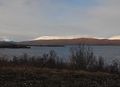
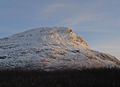
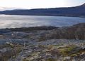
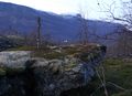
After a long time we reached the hashpoint and there was a very beautiful view over the ocean and the
City of Bjerkvik from that mountain, BUT it was so windy that we had trouble standing up, and the sun
was setting so it was going to get dark soon.
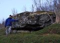
We hurriedly took some pictures of the GPS and us, and duct-taped a sign to a boulder that was located about 2 meters from the hashpoint.
All the trouble, steep inclines and particuarly the ravine we had faced going up made us look for an
alternative path down. We walked more to the north hoping to find a safer way down.
There was some trouble finding a safe path in the darkness since a flashlight only lights up small
parts of your surroundings.
After a little while we found the stream that came from the ravine and we crossed it to follow it on some sort of path on the other side. It didn't take long until we were in the middle of a forest with small streams and rivulets crossing our zig-zagging path all the time. Guinness got his feet wet on more then one occasion.
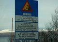
But anyway, we finally emerged from the woods and came down to a road (looking at Google maps afterwards tells us it must have been Småbergan Rd) and were walking south-southwest along it to our car when we saw some strange signs in the dark.. turning the flashlight upon one of them revealed the message "Fare Skytefelt": Danger, Firing Range!! And it was pointing into the forest we had come from! We had been on a military area that we did not know about! (Hey, we were in a foreign country.) Another sign warned about live ammunition and duds lying about; when we read the signs we remembered that when we left the car for our expedition we heard some automatic gunfire.
By pure dumb luck we had survived and were a bit amazed that there had been no signs at the point we started to climb, perhaps no-one expected anyone to be foolish enough to try scaling the mountain from that direction.
Now we only had 170km of road ahead of us to get home. One funny thing on the way home was a Norwegian man who had got low on oil in his VW-transporter and luckily we had one spare bottle of oil that he bought from us, so we got cash for caching :-)
We got home just after 9pm with the snow falling over Kiruna, tired but an experience richer.
Guinness and Jeppzer earned the North geohash achievement
|
Guinness and Jeppzer earned the Graticule Unlocked Achievement
|
Guinness and Jeppzer earned the Land geohash achievement
|
Guinness and Jeppzer earned the Restricted area achievement
|
Guinness and Jeppzer earned the Border geohash achievement
|
Guinness and Jeppzer earned the One with Nature Geohash Achievement
|
Guinness and Jeppzer earned the Geocashing achievement
|
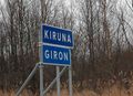
Leaving Kiruna
On the road between Kiruna and Norway
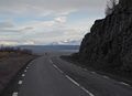
On the road between Kiruna and Norway
On the road between Kiruna and Norway
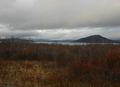
Mountain near road

Jeppzer in car

Guinness driving
Avalanche warning
Riksgränsen, near border between Sweden and Norway
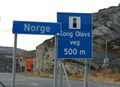
The Border between Sweden and Norway
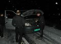
Border Control :-)
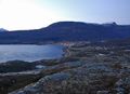
At sealevel starting towards hash
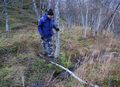
Jeppzer on way up
A little bit higher
A stone on way up
About 1/3 towards hash
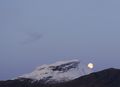
The moon came up
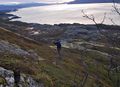
Nice walk
A small stone on way up
On way up
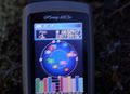
Blurry GPS :-)
On spot at hash
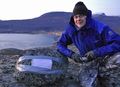
Jeppzer on hash
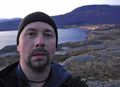
Guinness on hash
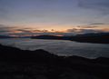
View from hash
View of Bjerkvik from hash
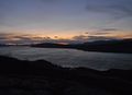
Sunset
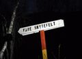
Danger Firing Range
Firing range!!!
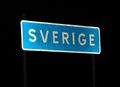
Back in Sweden :-)
You need oil in German cars also ;-)


- Meetup on 2008-10-16
- Meetup in 68 17
- North geohash achievement
- Graticule unlocked achievement
- Land geohash achievement
- Restricted area achievement
- Border geohash achievement
- One with Nature geohash achievement
- Gratuitous ribbon achievement
- Expeditions
- Expeditions with photos
- Coordinates reached
- Meetup in Nordland