2008-11-23 47 -122
| Sun 23 Nov 2008 in Seattle: 47.6929728, -122.0818286 geohashing.info google osm bing/os kml crox |
Contents
[hide]About
In Farrel-McWhirter park in Redmond. The google aerial photo doesn't match closely with a PDF map that I found. According to the PDF map, this geohash will be close to the "Parking", which doesn't show up on the google maps OR satellite. On the flip side, the google maps shows a road marked "service vehicles only" as the only one leading into the park. Farrel-McWhirter experts, please feel free to comment ;).
Also, for those bringing kids, I don't know what portion of the Barnyard and Playground are open. Thomcat plans to be there mid-day if the weather is at all decent, probably with family in tow, and we'll see what we can find.
Participants
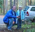
- Thomcat and daughter
Expedition
Thomcat
Downtown Redmond is across Lake Washington from Seattle; we took the Highway 520 floating bridge.
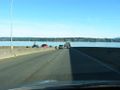
Light traffic!

It turns out the PDF map is accurate - the parking lot is shaped that way, and under the cover of a LOT of trees. So many that getting a signal was difficult at times. After finding the spot and taking the photos, my daughter and I headed off to see what we could.
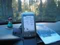
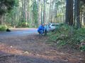
Close parking!
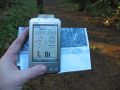
Close-up view


It was a perfect Sunday for football, although not for the hometown Seahawks, who were losing 20-17. The group we saw playing flag football was having fun, though.


This working farm is also accessible for petting, including a hand-washing station, so we met cows, bunnies and goats, and observed turkeys, ducks, chickens, and a big old pig.


Returning to the car, we chalked the pavement as close to the spot as we could, then headed back across the bridge. A perfect Sunday geohash expedition - Success!
