2008-12-19 32 -94
| Fri 19 Dec 2008 in Longview, Texas: 32.5141533, -94.7091078 geohashing.info google osm bing/os kml crox |
Contents
[hide]Location
After a week of watching the geohash circle the edges of the graticule, with me stuck in the middle without a bicycle, today's geohash marker popped up right inside the dot indicating the city of Longview. Yes! It was within four kilometres of my hotel room. Discouraged as I was from weeks without a geohashing success, I expected that it would be nevertheless unsuccessful, but I would still mount an expedition. I used Google Earth map view to zoom in on the point until it was only evident that it was near but not on an actual street, then switched to hybrid view to determine whether it was in a private horse paddock, a military installation or the city water reservoir. It seemed to be in lightly-wooded undeveloped land, but if there's one thing I've learned from geohashing in different parts of the world, it's that the same nondescript colour and texture can be a swamp, a burned out forest, a field or a firing range. I also knew from working here that the Google Earth aerial view is quite out of date and there could be new roads or subdivisions there.
Participants
- Robyn - hoping Longview locals will surprise her later today.
Expedition
I drew myself rough instructions to go south on 4th, east on Eden, take the south fork onto Marguerite, and so on, up to the point where I would have to either bushwhack or explore new roads. It wasn't strictly necessary to follow those roads, but how can you deviate without a plan.
The first part of the adventure went very well, despite Longview having no sidewalks. I just walked in the gutter and on people's lawns until I noticed a paved pedestrian path through the woods and going roughly in the direction of the geohash. So, spontaneously and adventurously, I took it. It emerged later on one of the roads on my route, and there was a traffic light there, so I used that intersection to cross a highway. I passed a rollerskating rink and continued down Eden Road. I wasn't quite on my route, but I was getting steadily closer to the geohash. Before long the numbers on the GPS blinked over from kilometres to metres. Nine hundred-odd metres to go!
The geohash was slightly to the right, and buildings on the right looked promising. There were fences, but behind the fences I could see parking lots and other evidence of open, publicly accessible space. Eight hundred metres to go and the right side of the road was woods. Woods with no fence in front. With seven hundred and fifty metres remaining the track to the geohash was at right angles to the road, as was a wide trail into the lightly wooded land.
It was like a dream about geohashing. The trees were pretty, and dense enough to suppress the growth of underbrush but widely spaced enough to pose no impediment to my passage. The ground underneath was dry and as firm as a race track. There were little gray squirrels, and light gray birds with white bellies, and finger-length lizards. The largest possible animal I could encounter would be a deer. With five hundred metres to go, there could still be a ten foot high electric fence, or another impassable barrier. I laughed out loud as I came to a winding stream than cut deeply through the woods. It was so narrow I could jump over it with a running start. And I did.
I'm thinking to myself that if someone who had no idea what Mother Nature could do imagined a MNIMB Geohash, this is what they might believe it was like. With 300m to go the brush became a bit thicker, so I detoured around the edge of the thickest part, and came out on a road. The geohash was across the road ... behind a church ... towards a fence.
Would it be before the fence or after the fence? With 90 m to go, the fence was about 90 m away. Step, look at GPS, step, look, step, look. Nine metres left. The fence is more than nine metres away. Victory is mine!
I photograph the GPS and me and suddenly realize that I am shielding the GPS from the sun. The clouds are gone! I have to go back to work! But no, it's just a momentary parting of the clouds. The sky itself is celebrating the end of my long geohashing drought.
As a complete coincidence, considering the amount I move around, I have geohashed an adjacent graticule.
Gallery
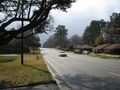
The streets really have no sidewalks here. It might be illegal to walk anywhere.

But rollerskating is allowed.
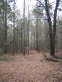
The way to the geohash includes a welcoming path in the woods.
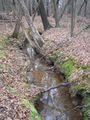
with a stream to jump over.
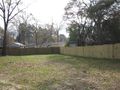
The geohash is right before the fence.
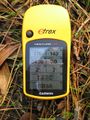
At the right place.
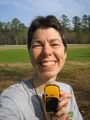
And the sun comes out to make my victory smile into a squint.
Where did that raptor come from?


