2009-01-11 48 12

| Sun 11 Jan 2009 in 48,12: 48.9460426, 12.0540563 geohashing.info google osm bing/os kml crox |
In a frozen, snowy field north of Bad Abbach, about 10km south of Regensburg.
dawidi
Initially we had planned to do the expedition in the late morning, but since we all got home late the day before and it was going to be a little less cold in the early afternoon, we decided not to start before 13:00.
Tomcat and Hans fetched me by car after lunch, and we drove to Bad Abbach. The car's navigation system suggested a different approach to the coordinates than we had in mind from looking at satellite imagery of the residential area south of the hash, and it turned out we were right. After a few minutes in a labyrinth of small roads going up the hillside, we found a parking spot 400m south of the hash and walked the rest of the way up the snowy hill, bathed in sunshine and nicely comfortable -8°C air.
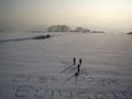
Tomcat's Explorist and my Vista GPS initially disagreed about the exact location of the hash, but this was due to a typo in his waypoint coordinates. While he and Hans started taking pictures, I walked around on the hard-frozen field and dragged my feet through the very dry, 2 to 4 cm thick snow to write "xkcd", and after realizing this was quite efficiently feasible, wrote "geohashing" on top and finished the artwork by adding "48 12".
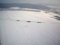
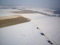
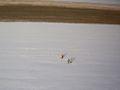
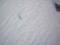
Since we weren't too cold yet, I deployed my R/C paraplane and did two quick flights, one with the on-board camera in horizontal and one in vertical orientation to document the location and my snowffiti from above.
We did not manage to build a snowman as the snow was too dry - it's simply too cold for the snow to be sticky. So we called it an expedition, took a few more group pictures and walked back to the car. While driving me home, we stopped in Prüfening to quickly log a relatively easy new geocache.
Video
The Video of the expedition, the making of the "snowfitti" and dawidi deploying and flying his paraplane above the hashpoint (including aerial photos) is available here.
Photos
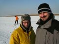
Hans and Tomcat at the coordinates. Dawidi starts walking funny to make a trace.
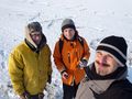
Full group portrait.

Ready to fly!
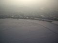
View south to Bad Abbach from above the hash.
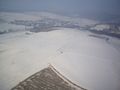
View northwest to Grasslfing.
View to the east.
View northeast to Niedergebraching.

Close flyover with text details.
View of the hash from the south.
Top-down view with bags, dawidi, Tomcat, Hans (left to right)
Low altitude view from the north.

On our way back.


