2009-01-12 48 8
| Mon 12 Jan 2009 in Pforzheim: 48.9716227, 8.1939858 geohashing.info google osm bing/os kml crox |
Location
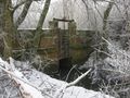
The hashpoint is in a field near Lauterbourg (France), just 200 m from the border to Germany and less than 3 km from the easternmost part of (mainland) France. It's accessible, though heavily guarded by large frozen chunks of soil at the time of the expedition. ilpadre and Ekorren went there. The 2008-12-18 hashpoint was just 400 m southwest, in what first appeared to be a giant cowshed (later it turned out to be a chicken farm).
Expedition
ilpadre
Watch the expedition video!
Ekorren
I was going to travel back from Heidelberg this day, and there would be enough time to spend on the way, so there should be a hashpoint to visit. When the coordinates were announced, I was a bit disappointed first, because the most feasible points were in my home graticules. But the one for 48 8 was in France - so, there were nifty achievements in for me, the area looked quite interesting, and, last not least, Ilpadre would join me on this expedition.
We agreed to meet at the main station of Heidelberg in the morning. Due to different plans for the afternoon we both had bought daypasses, but for different regions - anyway, there was one route where both tickets would be valid, and there was a reasonable connection that way. The local train to Germersheim should leave at 9:14 from track 5. Ilpadre was already waiting when I came running down the stairs to the platform, with him several dozens of other passengers, but what wasn't there was any sign of the train. The display showed instead a heavily delayed long distance train bound to arrive in a few minutes.
The scheduled departure time of our train arrived and passed, and then suddenly a voice spoke to us and it said that our train would go from track 2 today, and we joined the masses following the words of the voice, trecking back to the stairs.
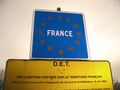
With only a few minutes of delay the journey began. We arrived in time at Wörth, a place well known to Ilpadre from a nightly double hash expedition a few days ago. But this time we would continue over a border that had been shifted so many times in history that people living there in former centuries stopped caring about whether they were supposed to be germans or french just now. Anyway, since the border finally came to a halt after WW II, the area is clearly french now. For us it wasn't very meaningful now, as it was among the first where regular border patrols were discontinued after the Schengen treaty.
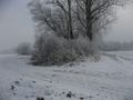
We left the train at Lauterbourg, now in France, and started on our quest, which should be an easy walk right on paved ways almost to the hashpoint. So the aerial picture showed, and so we believed. Anyway, on one of the first intersections we made a fatal decision to take a nicer looking route which was labeled with the much promising name Rhine view, and entered the winter wonderland of a large lake, which was a flooded sand excavation area.
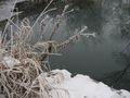
We had crossed a small creek so far, and followed the shore of the frozen lake for several hundred metres when our walk was suddenly stopped - by the track ending and turning into a small footpath, and by some flat red plate in french and almost german language. However, we are talking english here, so how are we supposed to understand what the sign tries to tell us? Also, some footsteps and a bike trail clearly indicated that the locals didn't care either. With the options being to go back almost to the start, or go on along the lake until there is some path to the left, we decided to follow the locals.
There still was a problem, and that was that the creek we had crossed earlier now flowed happily left of us, with the lake to the right, and our path on a narrow dam between them. What we obviously needed and didn't have, was a bridge. There was one - but with no possibility to climb down the dam at that point. Then there wasn't another one, but finally... the path ended and met a track on the backside of an industrial area, which we happily took as it seemed to lead more into the direction of the hash, so the worst should have been over.
After a number of left turns, the GPS showed that we were advancing the hash location again, and even in almost exactly a straight line - a happy feeling which was, after only a minute or something, interrupted by a sharp right turn. When the distance to the hash had climbed again to about 1.25 km, with no way to the left in sight, we took our chances on a bad forest track in a search for a possibility to cross the creek. Anyway, borders aren't really supposed to be easily crossed in the country, and here the creek marked the actual border to Germany, so if there ever had been something it was broken down. After some cross forest climbing we were back on the track we had been coming, and knowing how we had come here, and that there hadn't been a intersection at all, quite desperate for a shortcut.
We walked back for some hundred metres, and at the place of the shortest distance shown on the GPS, crossed a frozen field to take another chance on the creek. Which still marked the border and still gave no possibility to cross. Until... well, until it no more marked the border. And there it was. A bridge. Long before, we had been only 150 metres from that place. On a track that probably was supposed to connect to that bridge but made a sharp turn in the middle of a field. Simply ending with not even some steps down to the field, hidden behind bushes, we hadn't seen it on our first approach. However - if it's possible to climb on it, and cross that creek, it's the way to go.
Now back on something that can be named a track with no bad conscience, with no more creeks or borders between us and the hash, the distance number on the GPS declined fast, and we reached the last intersection where we should turn right on a way to the hash.
Only there wasn't an intersection because there was no way to the right. No doubt there once had been, the satellite photo clearly showed it, but all there was was a plowed field. Anyway, this wasn't the worst field we had crossed on our way, and a few minutes later we had made it - we were at the hash. Two hours it had taken, what was supposed to be an easy walk of not more than twenty minutes. Two hours of exploring an area of beautiful landscape, missing tracks, and evil creeks. But we had made it.
On our way back (we took the right way this time) we payed a short visit to a retro hash from not long before. Someone should have been able to claim a couch potato hash then, and judging by the sounds from inside the house, it turned out to be poultry. Prize poultry, maybe?
There was no chance to be back to the station in time for the next train, so we had plenty of time to go into town to buy supplies. Only that almost all of the shops there were closed. We succeded in buying a postcard and some french bread and crossed the border to get to a nearer bus stop and go back from there. Where we arrived in time and the bus didn't - it already had left two minutes before schedule. Bad driver (unfriendly he was also, provided it was the same who drove when the bus came back twenty minutes later).
Hashcard
Joanna certifies she received a hashcard from this expedition.
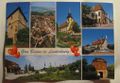
Gallery
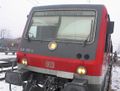
This is where we're going to.
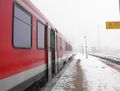
Train to Lauterbourg
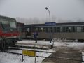
Station of Lauterbourg
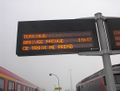
This train terminates here.
Somewhere in this direction we need to go.
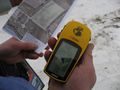
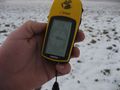
Programming the GPS
We shouldn't have passed this point.
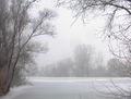
The lake

On a quest for bridges
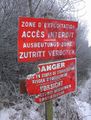
Follow the locals, ignore the sign.
Finally: A bridge!
Rural border crossing point
Somewhere here
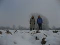
Been there
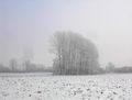
A view from the hashpoint
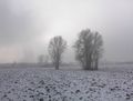
Another view from the hashpoint