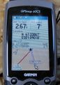
2009-01-17 67 21
| Sat 17 Jan 2009 in 67,21: 67.3238594, 21.1391970 geohashing.info google osm bing/os kml crox |
The hash was (presumably) on a mountain near Moskojärvi, about 2-3 km from the E10 road. the ru tried to reach it but suffered a humiliating defeat by Mother Nature.
the ru
After a quick trip to Kiruna to fuel my car and buy a spare set of batteries, I started driving south. I thought this was going to be an easy hash, but once I had put my skis on and headed into the forest I realized it wouldn't be.
The terrain was very unfriendly. The forest was very dense, and at any time I was going either up or down a very steep hill. I also ran into lakes and streams along the way. Being unfamiliar with the area I didn't want to risk crossing them. A wise decision, as I later found many places with open water.
Had I parked a kilometer further south, I would probably have avoided the water. Instead I had to find a way around it. It took an hour (including lots of tripping and cursing) to move the first kilometer and I wasn't even going in the right direction. Once I got past the water it became somewhat easier but the problem with steep terrain remained.
It wasn't quite Cliffs of Despair, but I finally reached a slope I couldn't figure out how to descend in a safe way. Since "breaking bones" and "getting impaled by tree branches" isn't on my fun-list, I decided to go back while I still had daylight. The hash was still another 1.6 km away and the GPS was pointing straight at a mountain.
I could have made it but it just wasn't worth it. This was an attempt to achieve my third consecutive hash and my first attempt in the virgin graticule 67 21.
the ru earned the Done with Nature consolation prize
|
Seems easy, right?
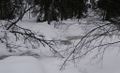
Open water
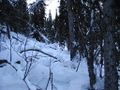
The terrain
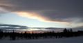
Sunset


