2009-01-24 49 -123
| Sat 24 Jan 2009 in Vancouver: 49.3650009, -123.3806584 geohashing.info google osm bing/os kml crox |
The Vancouver graticule geohash has fallen today on Bowen Island, an island three nautical miles off the mainland at Horseshoe Bay, served by ferries and populated mainly by artists and hippies. The geohash itself appears to lie exactly on someone's front doorstep on the island's main road.
Participants
- Robyn
- Twilightcity
- Adrian
Expeditions
Robyn
Despite the fact that there was an accessible geohash in a virgin graticule to the east, I was feeling cold and lazy, so chose the closer geohash. Options were to bike the 40 km to and from the geohash, or to take the bus to the ferry and then walk 4.5 km to and from the hash once on the island. For some reason, I decided the latter approach to be preferable. Biking just seemed like it would be cold and tiring.
While waiting at the bus transfer point I was approached by a deaf panhandler, so I chatted with her for a while. Okay, mainly she signed to me faster than I could follow and I nodded sympathetically and occasionally confessed to not understanding. I think she was just glad to have someone to talk to who didn't think she was drunk or insane. According to what I understood of her recitation, that is а common problems for the deaf.
The conversation attracted the attention of one of my fellow bus passengers, so I had someone interesting to talk to on the ride out to the ferry. He was going to Qualicum Beach to celebrate Christmas. They missed celebrating the real Christmas because everyone was snowed in and couldn't get together. He was going to Nanaimo, so we hung out in the ferry departure lounge, with someone else whom we spontaneously hooked up with, until my ferry came. Island people are more likely to talk to strangers than others. It's a good thing.
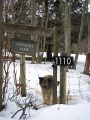
The ferry crossing only took a few minutes, then I started to walk the 4.5 km to the geohash. I figured that should take about 36 minutes, so I walked briskly up the road for 36 minutes and then turned on the GPS. Only 600 m to go. That took me up a hill, and around a corner until the GPS needle pointed 90 degrees to the road, in front of a long driveway, with 30 metres to go. I walked up the driveway beside a fenced-in field where two dogs barked enthusiastically at me. As I reached the top of the driveway and the house, the GPS counted down to 3 metres, right at the fence to the backyard.
An occupant of the house came out on the balcony above me and yelled at the dogs to stop barking. "It's me they're barking at," I called out. "Sorry about that." The dogs quieted down and I explained my mission. "May I go into your backyard to take some pictures?"
"Whatever," said the woman magnanimously, contented to have silenced the dogs.
I passed through the fence to point zero on the GPS range and took pictures of it, me, the dogs and oh look, there are llamas. I took pictures of the llamas, too. Then I called out a thank you and returned to the base of the driveway.
It was now about quarter to four. I knew that thepiguy, the other person most likely to turn up at a geohash on a llama farm on an island, was busy this weekend, so it was vanishingly improbable that anyone would join me, but I am a conscientious geohasher and I stay until the appointed four o' clock no matter what. The road was kind of too wet and busy with traffic to chalkmark, so I chalked a brief message on a piece of matting that was sticking out of a snowbank, and passed the time photographing and talking to the llamas and the llama-guarding dog.
Another man approached on foot, but turned into an earlier driveway on the other side of the road. And then I saw two cyclists approaching, up the hill. I watched them approach, and then one stopped in front of the driveway and pointed. "This must be the place," he said. I just stood there, probably with the geohashing trademark grin on my face. When they put two and two together and asked if I was a geohasher, I may have cackled with glee.
And then bafflement. I introduced myself but they showed no recognition. You'd think they might recognize the name of one of the most active geohashers in their graticule, and a very active wiki contributor. And they introduced themselves. Equally blank look from me. It turns out that they were on their very first geohash, do not follow the wiki, and didn't even know that four o' clock on a Saturday is the official meet time. They arrived at 3:55 p.m. by pure coincidence. The world is a great and beautiful place.
Twilightcity and Adrian are geography students. We reconvene at the ferry and then they give me a ride home, during which we discuss subjects such as urban development theory and Communism in France. It was a glorious day. This is the very essence of geohashing. Thepiguy is going to pound his forehead on something when he sees what he missed.
Twilightcity & Adrian
Adrian and I are both students in Human Geography at UBC. It just so happens that there's something in the water in our building, as most of us geo-kids are complete geeks for this kind of stuff.
We had decided to do the Sunday, January 25 geohash the week prior, but ended up deciding against it due to conflicts. Both of us had heard of geohashing before, but we had never actually gone and done it before.
Both of us are neo-luddites, so we didn't really have much to go on besides the reference on the Google Maps airphoto. Ironically (in the Alanis Morrissette way), if the hash would have taken place on Friday afternoon, I would have been able to make copies of the relevant Federal isarithmic (contour) maps from the Geographic Information Centre on campus (where I work), thus being able to come within a few feet of the point without assistance from any GPS equipment. Alas, that was not to be, so we decided to do things the "boy" way: blindly, with fingers crossed.
We drove out to Horseshoe Bay from my place in east Vancouver, me driving like a maniac to make it to the ferry on time. I swear, I left some motorists trembling in fear back on Powell Street. We zipped up the Upper Levels Highway to the terminal, re-assembled our bikes, bought our tickets and were relegated to the car deck like the two-wheeled pariahs that we were. The ferry ride was pleasant (and, for me, nostalgic) albeit uneventful. I think that we were on the same ferry as robyn, but not knowing her (yet), we did not meet her.
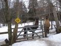
Upon landing at Snug Cove, we went to the Bowen Island library to see if we could find a copy of the map. Astonishingly, the friendly librarian who helped us out didn't have anything beyond a lot map, which didn't help us out any more than the Google Maps image. However, she suggested that we go to a place called "The Office" at Artisan Square, where they might be able to help us. As it turned out, they had a better map, but it still didn't help us, as it was not really cut out for what we were doing. However, the gent helping us (whose name escapes me) suggested we check it out again on Google Earth, which we did.
As soon as he saw where the point was, he said "oh, that's Gary and Vicki's house!" Of course, this is typical of Bowen Island, where everybody knows everybody. He followed this up with "they keep llamas." That's right. Llamas. Essentially, he said that the point was at the corner of their house, and to get there, we just needed to bike down the main road (a surprisingly steep trajectory!) past Grafton Lake until we saw llamas.
And that's what we did. We biked until we saw llamas, and then saw robyn walking up and down the main road. After encountering her (see above), we placed a message in a bottle (photos to be posted later), corked it and left it at the hash point.
We made it back to the ferry - the bike ride back being pretty damn awesome - and chatted about Douglas Coupland and other fun things on the way back. We really had no idea that there was supposed to be a 4 PM meetup...and thus revelled in the fact that we had made something unlikely (a geohash meetup point at a llama farm on Bowen Island) even more unlikely (two first-timers making it there with no batteries). Somehow, we managed to squeeze two bikes AND robyn into my piece-o'-crap car and hit the road once more.
We showed Adrian a bit of West Vancouver before driving back over the Lions Gate Bridge and retiring for the night.
For a couple of first-timers, it was pretty much perfect. I have a feeling that we'll be back soon.
Photographs
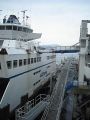
Foot passengers board the ferry through a top-deck gangway.
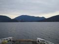
The ferry crossed to Snug Cove on Bowen Island.
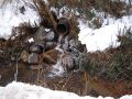
On the way to the geohash I passed some interesting ice formations ...
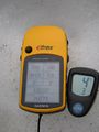
... but the temperature at the geohash did not qualify me for a frozen geohash achievement, even though the thermomter is lying there in the snow.
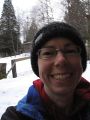
I was still smiling, however.
And there were llamas. Are we the first to find llamas at a geohash?
With a llama-protecting dog.
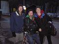
Here are Adrian, Twilightcity and me waiting for the return ferry.


