2009-01-30 52 6
| Fri 30 Jan 2009 in 52,6: 52.2268169, 6.7340878 geohashing.info google osm bing/os kml crox |
Plan
Arvid was at work, prepared for another standard cycling exercise round after work, when the hashpoint was revealed. Walking distance according to google: 13.4km. My cycling rounds are around 30km. So this was perfect since I don't work on fridays: This would finally become my midnight hash! On the dutch recumbent irc channel I asked if anybody had interest to come along, and the same guy that joined me on 2008-09-20 52 5 was interested. He has a new bike if anyone is wondering.
Achievements
- Arvid cycled 36.6km.
- Dragged along another recumbent rider.
- Midnight hash.
- Frozen Geohash at -1.4°C
Expedition
Arvid's tracklog by bicycle.
At 23:10 my dragalongee showed up at my place. But since my estimate for the 13km was "about half an hour" we only left at 23:22. We were insanely fast though, probably thanks to the slight wind from the east, we arrived at the point on the road closest to the hash at 23:48. That's an average of 30km/h while freezing. Not bad.
From 23:56-00:00 we were at the hashpoint, that was just into some woods next to the driveway of no 58. There were no fences at all, and the house was about 150m off the road, while the hash was just 50m. And obviously they didn't have any dogs outside. The place at the other side of the road did. It took a while before they noticed us, but their barking did become annoying at some point. It was a dark clear night, since there was no moon at all, nor were there any clouds. The cold wasn't too bad though. Usually these clear nights are the coldest, but this night wasn't very cold. I don't think it has been under -3°C all night.
I made a pic of my thermometer, and at 00:10 we set off again, but in the wrong direction, since this was also meant for exercise. Can't have an exercise of less than 30km, can you? My return trip was exactly 10km longer than the trip to the hash. I arrived home at 01:00.
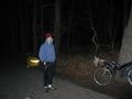
Bikes and dragalongee on the driveway.
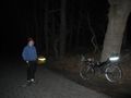
Now all of my bike on the pic.
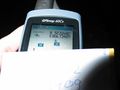
Coordinates exactly right.
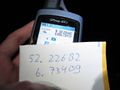
.7m off, but paper readable.
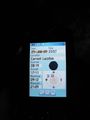
3mins too early!
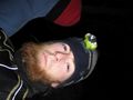
Me.

Dragalongee.
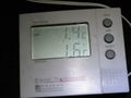
Slightly freezing.


