2009-01-31 48 12
| Sat 31 Jan 2009 in Landshut, Germany: 48.9971020, 12.2379434 geohashing.info google osm bing/os kml crox |
Among some trees, east of Barbing, about 10km east of Regensburg.
dawidi
I had originally planned to visit this location at noon, and maybe eat at a nearby IKEA afterwards, but spent several hours making a new time-lapse recording setup instead (soldering power cables, trying out ways to mount the camera etc.) and left just in time to make it to the coordinates before sunset. It paid off, though - the new wide-angle, ultra-wide dynamic range camera I used produced a far better image (progressive video at PAL resolution, even) than my previous setups with cheap webcams.
Here's the video: on Vimeo (high quality) or on Youtube
So, with the EeePC in my backpack and the camera strapped to the backpack's shoulder belt, I cycled against a strong eastern headwind through Regensburg and some industrial areas for 17 kilometers, until I arrived at the premises of "RAM - Regensburger Asphalt-Mischwerke", apparently an asphalt mixing facility. The GPS directed me to a small patch of forest just east of the facility, and I approached it from the far side. About half of the forest was fenced, but the hashpoint turned out to be within 3 meters of the unfenced part, so given an accuracy of 5 meters, I can presumably claim success without trespassing.
Then the usual procedure - take pictures, leave a weather-degradable mark (chalk in this case), eat some sweets to refuel for the ride back, drink something, and leave.
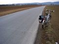
I continued north on the road, and drew a labeled line across it when I reached the edge of the graticule - at exactly 49° 00.000' north. On a slightly different route, I returned to Barbing, and cycled home with helpful tailwind, but cold toes.
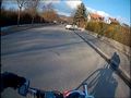
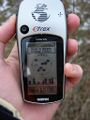
Still frame from the video.
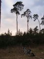
Accessing the hash from behind the small patch of forest.
The hashpoint, with fence.
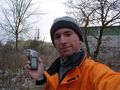
dawidi at the hash.
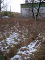
Well, close enough.

dawidi returns through the thicket.
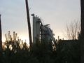
The nearby asphalt mixing facility.
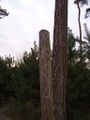
Marked a fencepost.
Re-entering my home graticule :)


