2009-02-05 49 11
| Thu 5 Feb 2009 in Nürnberg, Germany: 49.0123261, 11.9557567 geohashing.info google osm bing/os kml crox |
Near the south-eastern edge of the graticule. Under a tree in Schönhofen, on a patch of rocky, dry grassland of the Franconian Jura.
Tomcat and dawidi
Dawidi: This hashpoint was rather convenient - Tomcat and I had already agreed to meet that Thursday evening, we just hadn't planned where to meet. After the announcement of the coordinates, in a village 2.5 km from Tomcat's home, we knew where to go. I cycled uphill to Eilsbrunn after work, through a thick, freezing fog, arrived there at 19:15, and we walked through the darkness to Schönhofen. Parts of the track between the villages were covered by slippery ice, but not enough to make this a problem. The way up from the village to the hash was muddy, and arriving at the top, we realized why - a new house was being built there, and the construction machinery had conspired with the thawing to mess up the path.
Getting from the path onto the meadow (or was it a field? hard to tell at night) turned out ot be the difficult part: there was a steep slope of about 1.5m up onto the meadow. We managed to find a point where we could get my bike up, and walked the last 90m to the coordinates, to find they were under the branches of a tree.
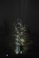
We put our LED bike headlights vertically onto the ground next to the tree so they illuminated its branches, and for about an hour, had fun taking pictures with various settings from multiple locations. We did not leave any physical markers or writings.
On the way back, the most problematic part was, of course, getting the bike back down on the path. Other than that, it was a nice, easy walk at night. Not too cold either.
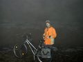
dawidi at his bike
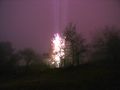
the tree at the hashpoint, illuminated by two LED bike headlights
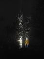
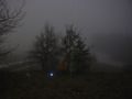
Tomcat and dawidi under the tree (from the south)
another shot from the north
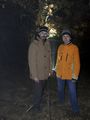
dawidi dramatically summons the great hashpoint marker from the skies
the hash marker mysteriously appears as a thin green line in the fog
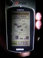
...here.


Tomcat earned the Walk geohash Achievement
|