2009-02-15 35 -83
| Sun 15 Feb 2009 in 35,-83: 35.3692524, -83.5834935 geohashing.info google osm bing/os kml crox |
Contents
Participants
- Luna diviner was almost there.
Expedition
Preparation/The Energizer Bunny Is A Lie!
My girlfriend and I ran into some difficulties from the start. We were hoping to get an early start by leaving home base around nine that morning, but both of us woke late. We finally got on the road around noonish, only to find out that our on-the-road GPS device had died on the day before during a trip to Asheville. So, we turned around to go back and get the charger. Now, as all young(er) people know, a bachelor's house isn't exactly the easiest place to find something, especially something as small as a charger cord. After fifteen minutes of fruitless searching, we decided to trust to Trimble Outdoors via Verizon Wireless to get us to where we needed to go. I grabbed my phone and off we went again, but not before writing down some basic directions and the coordinates.
A Scenic Drive/Are We There Yet!?
We set off up Highway 28, hoping it would get us there sooner. I did not count on my phone signal dropping off as soon as we hit the highway. Verizon has the best network, my arse. We kept to the road, and it eventually led us out on to Highway 24, where I picked cell service back up. At this point, I finally got a chance to play with Trimble, and had not found all the features of it yet. So, here we are driving along, and we cross a river. I'm going off my memory of Google Maps at this point, so I yell out, "Turn here!" "Here?" "HERE!!" (Yes, we have an ongoing joke from The Three Musketeers) Fifteen minutes later, I finally find the feature on Trimble I'm looking for: GPS coordinate entry. And as you've probably already guessed, yep, we were going the wrong way. At this point, we're in the small town of Wesser. (On the way, we passed the Nantahala Outdoor Center. For those of you who keep up with kayaking and such, this was the site of the 2004 and 2005 Olympic slolam trials. Now, my girlfriend is a professional photographer, and as such, takes photos of EVERYTHING! Including the Nantahala river itself.) So now that I've got the phone's GPS working correctly, we get ourselves turned around and head to the correct location.
Into The Backwoods/Google Streets Needs To Come Here
We make the correct turn (for once >_>) and start driving down the road, and see the most common sight of rural North Carolina: No Trespassing signs. They're everywhere: on every tree, on every driveway, even on most of the roads! Consulting my phone pretty frequently at this point, I point out that we're nearing the next road we need to turn on. Problem is, the road doesn't exist. We slow down, looking carefully for even a track through the heavy brush on the side of the road. Closest thing we find is a small creek. we soon arrive at the end of the road and come to one glaring conclusion. If we are to reach our hash, we're gonna have to walk a lot farther than we realized it, and most of it through some pretty heavy woods. Not one to be daunted, I turn us around and drive back to the creek. Despite our setbacks so far, I jump out of the truck fully stoked and fully stocked. I've got my no-rip camo pants on, with food in the cargo pockets in case we get hungry. I've got my backpack, with Nikon D70s and cellphone safely ensconsed within. And I've got my trusty machete handy, useful for marking trails or getting rid of pesky saplings. My girlfriend is laden likewise (minus machete, she's not cool enough to have one). Off we go, with high hopes and heavy packs.
The Walk Of Shame/Wouldn't It Be Gneiss...
If any of you have ever been in a mountain forest, one thing is abundantly clear: streams never stay in the same place over time. Walking beside that small branch, we realized this ourselves, as the entire slope was riddled with rocks from older, grown-over stream-beds. Electing to use the water as our guide, we set off up the mountain, checking the GPS every fifty feet or so. It was pretty rough going for a while, brambles everywhere, so we decided just to hop in the branch and walk up that way. Machetes aren't very useful without a good edge, and briars are one of the fastest ways to dull the edge. After thirty minutes of hiking up the hill, I pull my phone out to check our location, and it gives a warning buzz: LOW BATTERY! Now see, we're not even halfway there, and I would prefer not to be lost in this section of NC. Scenes from Wrong Turn are flashing through my mind at this point, and I turn my phone off to save what little battery life is left. I'm a stubborn ass, and I really wanted to make it to this hash, so like a fool, I kept going.
Hells Bells and Shotgun Shells/Get Off My Lawn, You Damn Kids!
So here we are, without any maps or GPS reciever to check on our position, on the side of a heavily wooded mountain I've never even seen, much less been to, and no contact with civilization. We're scratched and bleeding, wet to our ankles, lost in the boonies, and having the time of our lives. mere minutes later we find an old logging trail hidden up on top of a ridge and scramble up to walk it, thinking we might get somewhere now. Now the the going is a bit easier, we're actually making good time. Suddenly, we find ourselves on a road. A dirt road, but it's a road! Now bear in mind, it's been over an hour since we left the truck, and we've forgotten all about those signs we passed while driving. We begin to see some signs of civilization through the trees and eventually reach a house. Evidentally, the owner heard us coming long beforehand, because he's sitting on out his porch, chewing a wad of tobacco, shotgun balanced across his knees. He picks it up, cocks it, and casually points it in our direction while saying, "You're obviously lost. What do you want?" I'm not even ABOUT to try to be an ambassador with this guy, so I politely tell him we were just walking around out in the woods. "Well, you're not in the woods, now are ya, boy? This is my property. Dinya see the signs? Get off!" Okay. I'm not exactly the World's Fastest Man, but I can run pretty fast when I've got a shotgun pointed at my back; evidentally, so can my girlfriend. We finally stop running, gasping for breath when we're out of sight of the house. Most people would give up at this point and go home, but not me. There's a trail branching off to the side that leads in the general direction of the hash, according to the sun, so we start heading down it. It's pretty easy going, too, only a fifteen minute walk, but then we reach a crossroads.
No Way Up/The Cliffs Of Despair
Which way to go? The sun's finally starting to go down, and we don't have much time left. Impatient as I am, I don't want to waste any time; I've GOTTA get there! I set off jogging to the left, but only got a few yards before running out of room. Must be the other way. After another fifteen minutes of speedwalking, we come to the end of the trail. She's getting tired at this point, and her feet are starting to hurt. She broke her ankle when she was younger, and it's starting to act up. It's pretty clear that she's not gonna be going straight up the hill like I plan on, so I let her have the camera, food, and machete. None of it's going to do me any good on this climb. I mean, the hill's nearly an 80 degree slope! I lean foward to brace myself, and start up the mountain, using trees and saplings to pull myself up. It took me forever, or so it felt, but I finally reached the top. The sun is just setting behind the mountains to the west, and as I pull out my phone to check my location, I realize with a sinking feeling: We're not going to make it to the hash. Robyn is going to laugh at my pitiful attempts, because my phone tells me I'm not even close. In fact, I climbed the completely wrong direction. I don't have enough sunlight to go another 100 meters in the opposite direction, and it's starting to get cold. I slide my way back down the mountain, taking a few tree branches with me, to meet back up with my partner. We have enough time to take a picture of my phone screen before it dies, and just enough light to get back to the truck. For some odd reason, we got to the truck faster than to where we ended up. We drove home in the dark, spirits low, to report my first attempt and exactly how horribly I had failed in it.
Gallery
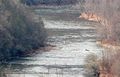
The Nantahala from several hundred yards away

Private is marked on nearly every sign.
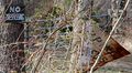
No Trespassing is marked on all the others.

My trusty machete
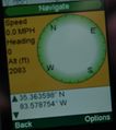
This is as close as the both of us got.
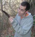
How I felt before we left


-Luna diviner 19:34, 18 February 2009 (UTC)