2009-02-22 30 -85
- Sunday 22 February 2009 - First known attempt in the Panama City, Florida graticule was foiled by natural, manmade and legal barriers.
| Sun 22 Feb 2009 in Panama City: 30.2803137, -85.8701622 geohashing.info google osm bing/os kml crox |
This try by geohashers/cachers Bos, B4Work and Roundnroundwego was vaillant but unsuccessful. Even with the technological advantages of GPS navigation, satellite imagery and Roundnround's Jeep we failed to reach the goal.
Geohashers B4work, Roundandroundwego and Bos earned the There might be alligators! consolation prize
|
Map and satellite imagery gave us the impression this would be at worst an easy 0.3 mile walk over well maintained logging roads; maybe even a drive up to within 20 meters. Woefully wrong, significantly over confident, hopelessly unprepared. As we crashed through dense brush B4Work, who is most experienced in the wilderness, remarked this is good aligator country. The way was barred by dense vegetation, murky swamps, flooded marsh, and tank trap like water-filled ditches reminiscent of castle moats. Probable easy approach from about 2 miles south was bared by a locked gate and no trespassing signs. Tried to upload Google Earth file of our track (.kmz file) but attempt was rejected by server. Bummer because track logs are most informative. Will try to set up a link. Meanwhile it is available via email upon request.
Lessons learned
- Do lots more homework
- Arrive early and scout the approach more thoroughly
- Bring boots at least to the knee for swamp penetration
- Swamps are more successfully navigated after a dry spell.
We'll be back.
edit by b4work
We find deer skeleton. Head, Jaws, Teeth, Legs, Ribs. Full but somewhat scattered bones
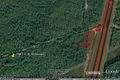
The path of failure
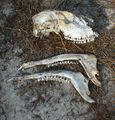
Juvenile Tyrannosaurs Rex Skull - Molars ? Well maybe it's a deer then.

