2009-02-22 32 -90
| Sun 22 Feb 2009 in Jackson, MS: 32.2803137, -90.8701622 geohashing.info google osm bing/os kml crox |
About
I introduced my oldest brother, who lives ~1100 miles (~1770 km) away, to geohashing a few months ago and he and I regularly check the daily points and encourage each other to attempt them when feasible. When I saw how close this point was to my daily excursions from my home into town, I knew he'd be calling me... which he did within 30 minutes of my checking the location.
Expedition
As it was a Sunday afternoon, after I got home from church and had a bite to eat, I was able to convince my oldest and youngest sons to accompany me. The "as-the-crow-flies" distance was only 1.48 miles, according to Google Maps, but seeing as where we live the roads are very unfriendly to biking, it would have been rather dangerous to attempt this Geohash via pedal power. Plus, the distance would have been a bit far for my youngest who's just 5.
We drove the quick 2 miles to the spot which is in an area that is being developed, slowly, into new homes. Not visible on the satellite image on Google Maps is a newly completed cul-de-sac road that meant we could park the car 90 feet from the geohash point. Given my adventures with brambles, briars and underbrush in the previous two excursions, that was most welcome. Also, since the land will soon be someone's yard or home, it has been cleared recently so it was a very easy geohash to reach. Additionally, there is a road in the first image hidden from view along the power lines. This is the main north-south artery that I take daily to get from my home and neighborhood into town for work, church and pretty much anything else. While the term "easy" is subjective, you'd have a hard time arguing that this wasn't a very easy geohash (hence the Easy Geohash ribbon)
My older son was most dismayed that it was windy and cold, hence his semi-scowl in the picture.
While we were packing everything back in the car, a father and son were nearby exploring some excavated dirt in an embankment and as we were leaving, I stopped and informed them that the reason we were taking a picture over in the middle of an empty lot was because it was the day's Geohash Point... of which they were, of course, blissfully ignorant. I gave a brief explanation and also indicated to them that we left a paper marker with the geohashing web address. He and his son made their way over to the point as we were leaving. Maybe there's now a new geohasing convert.
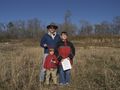
The Talbot Family Geohashers.
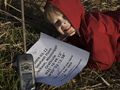
Benjamin mugs for the camera at the geohash point.


Uglystick has visited an Easy Geohash
|