2009-03-04 40 -74
| Wed 4 Mar 2009 in Newark: 40.5183833, -74.8142708 |
Planning
The geohash lies along the shoulder of US 202 N, just before Three Bridges.
Narrative
The location was so easy to get to, I wouldn't need a GPS. Or a map, or directions, nothing! After bridge Wednesday night, I would drive south on 202 to the Flemington Circle, swing around to 202 N, and take a picture of my speedometer.
It looked like another No batteries geohash. Except it was almost a run-home-for-batteries geohash: Halfway down to Flemington, the digital camera dies! Oh noes! I fish around in the car and find another pair on the dashboard. They may be dead, too, but I only need 2 or 3 pictures at most.
I get down to the circle, get pictures of some road signs, swing around to 202 N, and pull to the shoulder to take a picture of the highway sign. Click! I have my picture. Bzzzzt! The camera shuts down. The second pair of batteries is dead!
More rummaging finds one battery, still in the wrapper. Erk. Hopefully it'll be enough for one more shot.
I get back on the highway, bring the Venture up to the speed limit, and shoot the dashboard. Whew. Entering Three Rivers, I stop for a red light, and I take a picture of the crossroad sign. That one battery seems to be doing fine. I get a shot of the clock on the console, and a silly grin (okay, more of an arrogant sneer) for the gallery.
Gallery
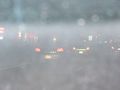
Hmmm, Pennsylvania drivers. This bodes ill.
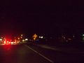
Approaching Flemington circle. Raising shields, arming photon torpedoes....
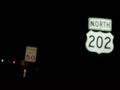
US 202 just beyond the circle. The speed limit steps up to 55 MPH a little further on.
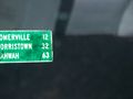
Approximate distance to Somerville, Morristown, and Mahwah.
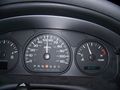
See, 54.5 MPH, I am a law-abiding citizen.
River Road, just beyond the geohash.

At this resolution, my brain is 5 pixels across.


Ribbons
Jevanyn earned the Speed racer achievement
|