2009-03-06 49 12
| Fri 6 Mar 2009 in 49,12: 49.0580113, 12.3296276 geohashing.info google osm bing/os kml crox |
Up in a larger mountainous forest area, not far from 2009-02-04 49 12, 6km north of Bach an der Donau, about 25km east of Regensburg. Probably an idyllic place, a meadow with a pond, several kilometers from the next village.
dawidi with Tomcat and Hans
We arrived - by car - at the hamlet called "Fischbehälter" ("fish container"... what kind of a name is that?), shortly before 18:00, i.e. around sunset. While it had been dry, but overcast in Regensburg over the day, up here we were found ourselves basically in the clouds. When we started our hike up into the forest on a very wet and soft, but not sticky path, it was still bright enough to go without lights.
We turned right at the first fork. After about a hundred meters, we found parts of the way were still iced over, and had to tread more carefully. At the next turn, we found that the way we had planned to take was blocked by a fence. So we tried to walk uphill through the woods, along the fence, hoping to find the way cross the fence again - but that didn't happen. After we had struggled for about 15 minutes, we decided to turn around because the snow was getting too deep and too wet and another fence completely blocked our way uphill.
Back at the first fork around 18:30, we decided to try the other option, which would be a somewhat longer route to the south. The path was wider, not iced over and comfortable to walk on, even though it was now dark enough to require flashlights. However, after a while and a couple of meters of elevation, snow and some ice started on this path as well. At the highest point, the way passed through cliffs, and we walked on for a while to see how the path would develop. Ultimately, after having made good only 400m of the 2.5km distance to the hash, we decided that even if there were no more problematic segments on the remaining route, it would be at least a 4km walk to the hash, plus all the way back, and we already had walked for about 1.5 hours and gotten our feet wet (because we weren't prepared for the deep snow), so we gave up and returned to the car.
On the way back, we wanted to look for a geocache in a "hermitage" quite deep in the woods - basically an open, tiny wooden hut by the side of the road, decorated with an uncounted number of icons, figures, pictures and books pertaining to various religions. Cleverly "hidden" among them was a school note book clearly labeled as the geocache logbook. The only problem was that while turning the car around to park next to the hut, we got it stuck in a seemingly innocent meadow (which just happened to be soaked with melt water) and had to argue and push to get it back on the road.
We also found another geocache while returning to Regensburg, and ate dinner at a crowded restaurant near my office before splitting up.
Even though we failed at the primary mission, overall it was still a very adventurous evening.
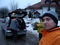
Start of the hike in "Fischbehälter".
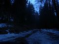
First we tried this path...
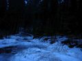
...then this one.
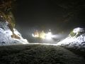
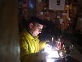
At the highest point.
Hans signing the geocache log in the hut.
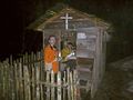
dawidi and Hans at the hut.


