2009-03-09 38 -91
| Mon 9 Mar 2009 in Washington: 38.2501798, -91.0751560 geohashing.info google osm bing/os kml crox |
Contents
[hide]About
Today's hash was on a steep hillside overlooking the Meramec River just downstream from Missouri's Meramec State Park. Appropriately for geohashing, it was also not far from the so-called International Friendship Park.
Expedition
excellentdude: This day found me heading from my girlfriend's house in St. Louis, Missouri, to my parents' house in Warrensburg, Missouri. There are two main ways across the state at about that latitude. There's Interstate 70, a four lane freeway all the way across the state, and US 50 Highway, which is only two lanes for well over half the journey. I've traveled the latter before, and it was quite scenic and enjoyable. When I checked the day's geohash coordinates, I found they weren't far off of 50 Highway. Furthermore, they were very close to the Meramec River. I had floated this river a few years ago just upstream from the coordinates, so I knew I was in for some good scenery if I checked out the hash. So I did!
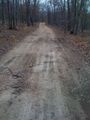
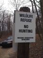
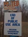
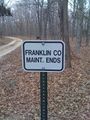
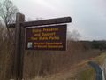
The directions Google gave were pretty good and got me as far as I could go on public roads. A theme for this geohash, more than others I've been on, was that the roads kept getting worse and worse as I approached the hash. While this is typical, the range was large: eight lane freeway to barely perceptible as a road. I got off the freeway onto a state highway, then onto a secondary state highway, then onto a couple county maintained gravel roads. Where I needed to stop on the last of those just happened to be where the county maintenance for that road ended. I parked at a gate to a private driveway on the edge of Meramec State Park. There were signs posting the edge of the park and the owners of the private land not wanting various things to happen on it. As trespassing or soliciting weren't mentioned. Since the driveway appeared to go in the general direction of the hash, I decided to walk up it and see if I could get permission to go to the hash.
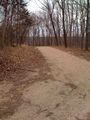
The driveway turned out to be fairly long. I walked along as it twisted and turned between trees and clearings. The quality of the driveway got worse and worse as I went. Finally, after ten minutes, I arrived at the house. I knocked at one door and no one answered. As it wasn't really clear which of the two doors was the front door, I knocked at the other door. There was still no answer. From what I could see of the house, I began to wonder if it was abandoned. If it was, it was only abandoned recently (sometime over the winter) because the grass was still short. The hash was not too far from the house, so I decided to go for it.
To make my way there, I had to take this apparent branch off of the driveway. This was the final road that was barely perceptible as a road. When I got to a point where my latitude was about right, I proceeded west down the steep forested hillside to get the right longitude. I wasn't sure how close the lines had to be on the terrain map for it to be too steep, but now I'll use this place as my gauge. It was steep, but I could still barely get around in my tennis shoes. I got pretty close to the exact spot, then decided I needed to go a little farther north to get the exact coordinates. But then the latitude on my GPS jumped, and I was apparently too far north. So, I turned and went in exactly the opposite direction (which I thought was south), and the latitude on my GPS continued to increase. Being in the northern hemisphere, I was somewhat perplexed. I wandered around and got screen shots of three different GPS readings. I posted the most accurate one and pictures of that location below.
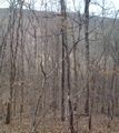
While on the hill, I saw some flat brown at the bottom that I thought was the Meramec River. Later, having compared my photos and location to the satellite photos, I think it was actually just a clearing with the river at the edge of it. Having gotten everything I came for, done a little hiking, and seen a little scenery, I headed back to my car at the end of the long driveway. I took photos on the way out of what the driveway and roads were like. When I got to the end of the driveway and was taking pictures of the signs there, a park ranger drove by. As I was getting in my car to leave, he came back by from the other direction. He looked at me for a bit, so I nodded, got in my car, and followed him back down the road. After a short distance, I stopped and got a good picture of the river over a hillside. I then continued on and caught most of the way back up to the park ranger when I decided to stop and take a picture of the tall trees that were lining the road. When I did this, he pulled off the road and stopped. I thought he was going to either turn around and come back to me. He didn't, but when I resumed he followed me for several miles. He eventually turned off somewhere else before I got the pictures of the river from the bridge about five miles upstream from where the hash was. So, fortunately for me, there was no Police Geohash achievement to be had this day. After I got the river pictures, I continued on to my parents' house.
Achievements
excellentdude earned the Land geohash achievement
|
excellentdude earned the Graticule Unlocked Achievement
|
Photos
At the Hash

Obligatory goofy grin
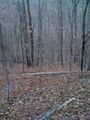
The hash itself provided a nice log to sit on for a break
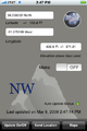
Best reading I could get after three tries
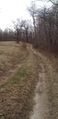
Either the river or a clearing at the bottom
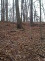
The incline to get back to the road


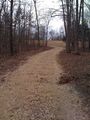
The Roads and Sites Along Them
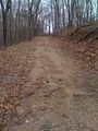
The last "road" near the hash
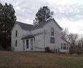
The house in question
Starting to head back to the car
Still going
And going
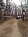
The end of the driveway where I parked
Leaving the property, entering the park
Entering property, leaving park
The road beyond the driveway wasn't good either
Moving along
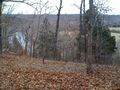
A clear shot of the Meramec from the side of the road
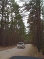
Last road before pavement and park ranger


Better Shots of the Meramec River Upstream
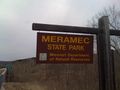
The highway goes through the park
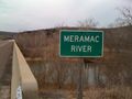
No question about the river now

The Meramec River!
Time to go


