2009-03-11 52 -0
| Wed 11 Mar 2009 in Northampton: 52.0756037, -0.1407393 geohashing.info google osm bing/os kml crox |
Contents
[hide]Location
Almost directly on a public footpath running through a field in Guilden Morden, just southwest of Cambridge.
| This expedition was part of a multihash by Benjw. For the other parts, see: | |||||
|---|---|---|---|---|---|
| 2009-03-11 52 0 | 2009-03-11 52 -0 | ||||
Participants
Expedition
Benjw
Starting out from the hashpoint in the Cambridge graticule, it didn't take me very long to get to Guilden Morden village, where the Northampton graticule's hashpoint was located. The two GPS photos (here and here) show that I took 54 minutes to get from one hashpoint to the other (it could have been much quicker if it had occurred to me to rush). I wonder if that is a 'speed record' from hashpoint to hashpoint?
The hashpoint was in a field of cabbages, but was only just off a public footpath. The field had been planted all over, but the public right-of-way through the field was identified with white marker flags. Happily, the cabbages were big enough that I could easily step between them, rather than on them, so no cabbages were harmed in the making of this hash.
I took a few more photos of this pretty village, and headed home.
Shiny ribbons earned
Benjw earned the Land geohash achievement
|
Benjw earned the Multihash Achievement
|
Photographic documentation
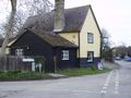
Sadly the pub was closed.
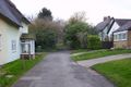
A nice residential street leading to the hash.
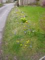
Pretty spring flowers.
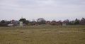
Guilden Morden village, from the footpath.
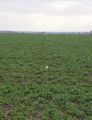
The right-of-way was marked through the field.
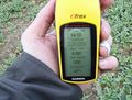
Proof of hash.

Ben in a field of cabbages.
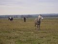
Geohorses in the next field.
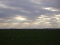
The sun shining through the clouds.


