2009-03-17 31 34
| Tue 17 Mar 2009 in Beersheba: 31.9794568, 34.9238954 geohashing.info google osm bing/os kml crox |
Today's hash fell in a very accessible location, among some trees in the middle of Kfar Truman, a small village ("Truman village") across the highway from Ben Gurion Airport.
Contents
[hide]Participants
Yerushalmi and his wife.
Expedition
Yerushalmi and his wife left Bar-Ilan University at around 6:00pm. This is after a week and a half of badgering her to try this, so he claims the Drag-Along achievement for this.
In planning the expedition, I took:
- A satellite picture of the hash point from the closest Google Maps was able to zoom in;
- A road map of the turnoffs we would need to take from Route 1;
- The English version of the diplomatic passport. Now, the satellite map looked like it was in public property -- some random small set of woods between two roads -- and anybody I might want to convince if it did happen to be private property probably wouldn't read English well enough to understand it, but you know, just in case...
- Two Cameras
- Two cell phones (we were carrying them anyway...)
- No GPS, because we don't own one. No Batteries Achievement ho!
We started out traveling south on Route 4 in Elphaba (our trusty Mazda 2) then east on Route 1. We took the turnoff onto northbound Route 40, then east on 453, my wife taking pictures while I drive. So far so good. There's a nice big convention center across the street from our next right turn into Kfar Truman. I notice immediately after the turn that there's a gas station with a small convenience store -- why not go buy some food and go for the Picnic Geohash achievement? We bought a bag of sour cream and onion potato chips. This arose out of a misconception as to what legally constitutes a "picnic". Oh well.
We continued straight on Rechov Haela. There are considerably more turnoffs on this street than I thought there would be according to Google Maps, but I know I'm waiting for the road to split in two. At some point we reach a traffic circle. I don't remember a traffic circle being on the map... I pull over a bit, look at the map, and yes, there's the traffic circle. The road splits in two right there! Okay. Take the right road for a bit, wait for a place to park...
We park on the first street of two in what is marked in Google Maps as Extension B, called Rechov Hazayit (Olive Street). We got out of the car and headed west; a close look at the map had told me that there were two circular clearings connected by a path, and the hash point is in the center of the western clearing. Well, I don't see any circular clearings.
Oh. The hash point is in the woods EAST of Extension B, not west! So we head back to the car and drive forward a bit, passing the second of the Extension B streets, and park on the side of the road. We pick up all our stuff again and start walking down the street. Since we're loudly debating where exactly the hash point is, some guy across the street walking his dog asks us (in Hebrew of course) if we're looking for something in particular. I chicken out trying to explain to him and just answer, "Nothing you can help us with, sorry," though in retrospect I should've asked where the Sports Center that's mentioned on the google map is.
We reach an intersection; the map I had printed out, unfortunately, didn't include the name of that street, so we didn't recognize it. I was certain the hash point was *past* this intersection, because I thought the hash point was a lot further along than we had yet gone, and because Google Maps had already neglected to inform us of a few turnoffs along the way. But we decide we should at the very least turn into the woods now to start looking for the circular clearings.
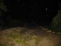
Well, we walk into the woods across the street from the intersection, and the very first thing we come to is a circular clearing! It's got a big stone in the middle with a dedication to President Harry Truman, after whom the village was named (photograph below). The rest of the clearing is a playground for the kids of the area. But I'm still convinced we haven't walked eastward enough to get to the hashpoint, so we head east more to a second section of playground. At this point I notice that there *are* no further clearings to the east, so I figure this is the east clearing and the previous one, with the Truman dedication, is the west clearing and the hashpoint.
So we head back to the previous one, declare the expedition a success, and crack open the bag of chips. In the midst of celebrating our first successful geohash (land geohash, and no batteries), the first geohash in the graticule, and in fact the first geohash in Israel, we notice two things:
- Among the animal statues around the playground is a whale and something that looks suspiciously like Pikachu;
- The map shows that the EAST clearing is directly opposite the intersection, and the clearing we're in is directly opposite the intersection. So we're *not* at the hashpoint. And there's a path leading from this playground heading west...
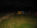
So we move off west. The path leads us to the REAL west clearing -- but I notice that in the center of the clearing is what we call in Hebrew a "caravan", which doesn't actually mean caravan, it means trailer. I'm getting concerned that we're heading onto private property and that we'll either end up with an Ambassador achievement or a No Trespassing consolation prize.
That's when my wife points out that there's a Magen David on the wall of the trailer. Several, in fact. Many, in fact. It's a synagogue! Closed, darkened, and locked for the night, of course, but this is the village synagogue, in a trailer next to the childrens' playground. We take dozens of photographs, circle the entire trailer in order to make sure that we either hit the hashpoint or got within two meters of it (it's not a very big trailer) and I start celebrating the Holy Hash achievement. Then we head home :)
Now, here's something for you geohashers to argue about: The Holy Hash achievement states that "It is important that the coordinates have been officially consecrated - that is, by a priest of the according religion." But Judaism does *not* consecrate the grounds of its synagogues and other places of worship. In fact, Judaism does not consecrate any ground at all -- except one. The entire Land of Israel is considered consecrated ground under Judaism. Some more so than others -- for example, the Temple Mount -- and there are disputes as to how far the consecration extends (for example, most opinions hold that the port city of Eilat is too far south to be part of consecrated Israel, and there are actual practical religious laws that arise out of this...).
So I know I have the Holy Hash achievement from this expedition. But do I have it because of the synagogue? Or do I have it because of Israel? If the former, the definition of Holy Hash needs to be changed. If the latter -- EVERY Israeli geohash point is a Holy Hash.
Photo gallery
More pictures may or may not be forthcoming, if the second camera gets working again.
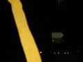
The entrance to Kfar Truman.
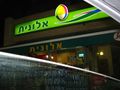
The Alonit convenience store, where we bought potato chips.
It's Pikachu!
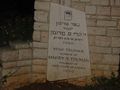
A dedication to Harry Truman, after whom the village is named. We thought this was the hashpoint...
...until we noticed we needed to go thataway.
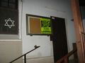
And the real hashpoint has a synagogue!
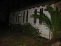
The side of the synagogue.


Achievements
Yerushalmi earned the Drag-along achievement
|
Yerushalmi earned the Land geohash achievement
|
Yerushalmi earned the Holy hash achievement
|
Yerushalmi earned the Graticule Unlocked Achievement
|
Yerushalmi earned the No Batteries Geohash Achievement
|