2009-03-18 49 10
| Wed 18 Mar 2009 in Bamberg: 49.8034528, 10.1320614 geohashing.info google osm bing/os kml crox |
Location
Today's location is in a field near Dettelbach.
Country: Germany; state: Bayern (Bavaria, EU:DE:BY); administrative region: Unterfranken; district: Kitzingen
Weather (14:30): Great! Sunny, 13°C
Expedition
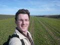
Danatar
I used my bike to get to the student cafeteria and continued from there after lunch. The weather was great, so cycling was really nice. Then my pedal started to get loose again. It seems yesterday's attempt to repair it did not work. Every few kilometres I had to stop and fasten it, but those were the only problems I encountered. When I was pushing my bike up a very bad and steep part of the track 100m from the hashpoint, I met a group of about 20 old people hiking: "We would applaud if you would be cycling this part." (No thanks); "Nice day, isn't it?" (Yes); "Where are you from?" (Würzburg); "Are you going to Volkach?" (No, I'll keep cycling around these fields here).
The hashpoint was in a field with small cereal plants, but there were tractor tracks going through the middle of the field where no plants were growing and I did not have to trample anything. I snapped some photos and cycled back. The hikers might have wondered why I was returning already. In Rottendorf I made my usual stop at the bike outlet store and bought a new pedal, I hope it works.
Total distance cycled (including detour for lunch): 20.2 + 16.2 = 36.4 km ; Uphill: 260 m
Coordinates reached