2010-06-12 49 10
| Sat 12 Jun 2010 in Bamberg: 49.8070820, 10.1346896 geohashing.info google osm bing/os kml crox |
Location
Today's location is at the edge of a wheat field near Dettelbach. The hashpoint is 450 m from 2009-03-18 49 10 and 850 m from 2008-10-06 49 10; srs0, thepiguy and Danatar cycled along the track 50 m from the hashpoint on the ill-fated 2009-06-02 49 10 expedition (tracklog on that page), so it's almost a déjà vu.
Country: Germany; state: Bayern (Bavaria, EU:DE:BY); administrative region: Unterfranken; district: Kitzingen
Weather: mostly clouded with a little sunshine
Expedition
Danatar
In the morning the weather didn't look nice and there was even a little rain, but in the afternoon the sky was only clouded. Shortly after 3 pm I started and cycled along my usual route east to Rottendorf, Effeldorf and Biebergau. I went past the 2009-03-18 hashpoint and stopped near the hashpoint at about 16:05. In the field on the other side of the track a farmer was bringing out water or pesticides, but when I stopped he drove to another field further away from the hashpoint. When I was a few metres away from my bike, I heard a sound in the wheat field next to me. A hare ran out of the field and fled; a second one also ran out of the field but turned back instantly and vanished. I walked on the edge between a wheat field and a sugar beet field until I was 5 metres from the hashpoint, then stretched my arms towards the spot and decided "near enough".
Afterwards I cycled to the 2008-10-06 hashpoint for a quick photo, then I went home.
I cycled 35.4 km and 280 m uphill.
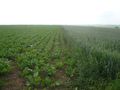
almost there
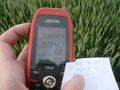
GPS

coordinates reached
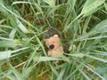
hashhog in the hashfield

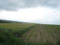
panorama
2009-03-18 49 10 hashpoint

2008-10-06 49 10 hashpoint


