2009-03-19 48 9
| Thu 19 Mar 2009 in Stuttgart, Germany: 48.3593302, 9.2229452 geohashing.info google osm bing/os kml crox |
About
The hashpoint is in the Schwäbische Alb elevated hills, at about 800m above sea level, in the Sonnenbühl municipality near the village of Erpfingen and the famous Bärenhöhle (bear cave).
Expedition by Ekorren
It was rather warm and sunny all week, and each day I was prepared to go on a geohashing expedition, but the coordinates turned out too far away. Well, and then came thursday's coordinates. Those weren't very near, also in the mountains again, so no easy terrain for a bike expedition, but reachable. I had all day to get there and back anyway.
The day before I had fixed some issues with the bike, and wasn't entirely sure whether it had turned out good. This basically affected the brakes, so I packed a number of tools and prepared backup plans like avoiding the 20% downhill slope on the standard route back, or taking the one train there is on schooldays from a station near the hash.
Now choosing a route to go. Taking the same as on several trips before would be boring. On the other hand, there are lots of recommended bike trails shown on the topographic map, so, accepting only a little bit of additional slopes, I could pass some places where I had never been before. Also, there was no hurry. Past expeditions had taught me to be very careful with smaller roads and tracks up into the mountains in winter, but with almost a week of warm weather, the snow should have been gone for good by now. So I believed. I was wrong.
Until Öschingen I took the same trail as for 2008-11-29 48 9. On the way, somewhere at a forest clearing I passed a few Giant Sequoia trees - actually I had passed there a number of times before but not realized them. You don't think that's special? Well, mind that they aren't at home in europe, and are usually referenced as being "a rare sight in parks". In forests you won't usually find them - except in the former small kingdom of Württemberg. So, here's the story:
In 1864 King Wilhelm I of Württemberg ordered one pound of sequoia seeds to get them planted in one of his parks at Stuttgart. A common theory states that, when ordering the seeds, they expected to get one pound of cones, but actually recieved one pound of pure seeds - which is a number of about 100000 pieces. Wasting anything you have paid for isn't something suabians would ever consider, so these seeds were actually sown, yielding about 7000 young plants. As these were far more than they needed at Stuttgart, the leftovers were distributed to other places in the kingdom and even sold to private people. Many plants didn't survive the cold winters, but about 200 of them have been tracked down to still grow happily in the old kingdom.
Now, back on track. I passed Öschingen and went for the Filsenberg nature reserve. A public road should lead up the unavoidable steep slope to 800m, continuing as an agricultural track into the hills, and both of it was marked as a recommended bike trail on the map.
A few hundred metres after the village, the road turned into a gravel track. Then it got wet. And then... there was snow. Heck, it had been about +10°C for days, where did that snow come from? Ok, this was one of those side valleys where the sun never hits the ground, and where the wind leaves the snow it picked up on the mountains, so it will probably be better when reaching the sunny plains. So I believed, and somehow I reached the top.
Now, there was still plenty of time, so a detour to a famous viewpoint would be nice. After all, it's a nature reserve also, and those usually aren't declared without a reason. Forbidden to leave the marked ways from April 1st - marked ways? There's a marked way somewhere? Hm... if you call a single sign which says Teufelsloch 800m a mark, and call a few footsteps in a meadow a way, there is.
The view from the Teufelsloch (=devils hole) was worth the detour. The cache at that place wasn't, as I didn't find it and the announced terrain class of 2 probably wasn't correct either.
When I got back to my bike, it was already about 13:50. Later than expected, but still no hurry. So I believed.
Now, where's the bike trail to Willmandingen? Er... the map says it's here, there's also some sign... but all there really is is a muddy meadow, covered with sticky snow, a mess of glue that takes off your boots on stepping in. Not a single bit of gravel, and that's what they call a bike trail. Not a mountainbiking one, that is. There is another markup for those.
There was no choice. Going back to try another trail would mean to go back for several kilometres and down for more than 200 elevation metres, on a partly iced track, and who knows in which condition the other way would be. Sneaking on left hope it would get better. It actually got, after reaching the forest tracks again, which took more than half an hour - for less than one kilometer.
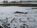
Back on clear paved trails, it was now only one more hour through the hills to the hash, which I reached around 15:45. A strong and cold wind had come up, so I restrained from leaving my paper marker (would have been blown away anyway) and used the leftover snow instead. Around 16:00, I left again and headed home.
One hour later, still before I was back down from the Alb again, a sudden "fzzzz...." ... damn! Only a few weeks ago, the back tyre tore on the expedition to Horb, now the front tyre followed its example. I had been prepared for several possible problems with the bike, but that one was not among them. At the most inconvenient location it even happened, as from here it would mean pushing the bike for far more than ten kilometres to reach any train station. On a narrow and heavily trafficated secondary road in the mountains. There could be buses, but the buses don't carry bikes.
So what are the options? Leave the bike somewhere and come back with tools and spare parts? Actually, that's a nasty option but the most realistic one, so I went for that, pushed the bike into the next village and was lucky to find there still was a bus away from that village that evening. And even more lucky when the driver agreed to make an exception and let me take the bike on the bus. I didn't mind where the bus actually went, as long as there would be a train from there back home that day, honestly.
Gallery
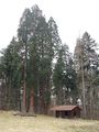
Giant Sequoia trees - an uncommon yet not entirely rare sight in the former kingdom of Württemberg
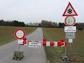
Road closed because of toad migration
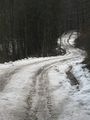
I hadn't expected any more snow or ice. I was wrong. This is a public road, btw.
Rossberg with viewtower. Need to go there some time.
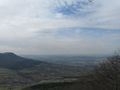
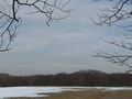
It looks all so flat from above...
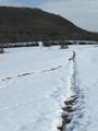
The recommended bike trail actually was a muddy meadow covered with sticky snow.
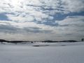
Snow on the plains
This classical bus stop sign was supposed to be replaced by a newer model about twenty years ago.
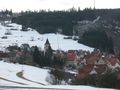
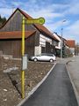
Today's hash village: Erpfingen
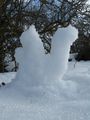
It's actually about living size, no matter how large it looks on the picture.
Marker
yawn


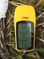
Tracklog
... is here.
Google maps terrain view might give some wrong ideas (actually it shows ~730m for the location of a 801.5m landmark). Way back intentionally left out this time.