2009-03-20 49 11
| Fri 20 Mar 2009 in Nürnberg, Germany: 49.0493722, 11.8020963 geohashing.info google osm bing/os kml crox |
In a small chunk of forest on a former military training range near Hemau, 20km west of Regensburg.
Tomcat, Hans and dawidi
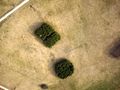
Dawidi: Immediately after hash o'clock on Thursday, the peculiar-looking satellite view of the surroundings and the accessibility of this hashpoint was discussed on #geohashing. An aerial image was found (the hashpoint is on the far right), and while official topo maps designate the area as a St.O.Üb.Pl. ("Standortübungsplatz", i.e. a military training range), Hemau's Wikipedia article suggested that the military base had been shut down in 2003. So, chances were good for the area being accessible.
Tomcat said he'd like to go there by bike, as one of the battery packs on their electric power-assisted bikes had become lazy over the winter and needed to be reactivated to return to its full capacity. We met on a bridge in Nittendorf about an hour before "official" sunset, and continued on a cycleway along the federal road B8, continuously downhill to Deuerling, up a steep slope to Pittmannsdorf, and then straight on through Hohenschambach. When we arrived at the forest surrounding the training range, it got dark enough to require lights on the bikes. I remembered the route into the area that I had chosen from the satellite imagery, and the tracks turned out to be open and accessible. There were a couple of old, rusty warning and no-trespassing signs on the edge of the forest, but it was obvious they didn't apply anymore.
The large meadow with the rectangular and circular patches of forest, which had looked so peculiar on the satellite images, seemed rather normal in the last light of the day. The meadow was rather bumpy, but we managed to push our bikes to the edge of one of the patches of forest and then wiggle through the dense trees to the exact coordinates.
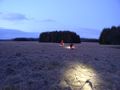
When we emerged from the forest again and sipped tea and ate cookies at our bikes, the stars had come out already. This far from the city lights, i could make out a few more constellations than usual. It was getting pretty cold, though (we hadn't really expected this would be a Frozen Geohash), so we hurried to get back on the road. We cycled silently through the darkness back to Deuerling, where we decided to take another route through the Laber valley, which would mean flat road almost all the way to Eilsbrunn. We arrived at their home around 20:30, and had a nice dinner before I rode the last few kilometers downhill to Regensburg.
Having to keep up with two guys on power-assisted bikes, once again, turned out to be quite taxing for me, even though we're not trying to outrun each other - but maybe the fact that I can compete at all also comments on my fitness in a rather positive way :)
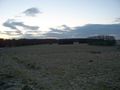
The large meadow. Not looking so peculiar from here.
Approaching the small forest.
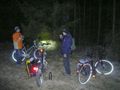
We parked our bikes at the edge of the forest.
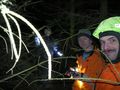
Portrait in spooky brushwood at the hash: Hans, dawidi, Tomcat.

Garmin Vista, Eten Glofiish M800 (running SirfTech), and Magellan eXplorist 500 at the hash.
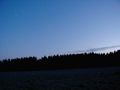
Starry sky over the meadow.


Note on the "Glofiish": obviously it's a GPS-enabled WindowsMobile smartphone. I had ordered it last week, hoping it would replace my Garmin Vista and my old cellphone, offering better GPS sensitivity with a builtin SiRF3 and allowing me to use cached OSM or Google Satellite tiles for navigation instead of vector maps. However the device doesn't run even remotely stable enough to depend on, half of its buttons activate anytime you accidentally touch them while the other half needs to be poked with a fingernail to respond, and I couldn't get gpsvp to accept GPS input from the SiRF3, even though using SirfTech I managed to configure the receiver to use the correct protocol and baud rate. Also, battery life, general ruggedness, and the shiny screen's daylight readability are a total fail, compared to the dedicated Garmin GPSes I'm used to. I'm returning it and will probably buy a Vista HCx (and a new minimalist cellphone) instead.
2009-04-05: dawidi and Tomcat
We went here again on this nice sunday morning to fly our model airplanes over the area and to hide a geocache at the coordinates. Thought I'd share the images :)
Tomcat also recorded an aerial video of the area from his Multiplex EasyStar.
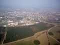
View of Hemau from the hash
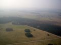
The hash is at the right corner of the square-ish patch of wood...
which is the front left corner in this lower view.
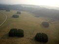
The hash from above. We're standing at the track in the top left corner.
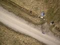
Tomcat at his EasyStar plane, dawidi in the middle of the track.


