2009-03-27 31 -85
| Fri 27 Mar 2009 in Dothan, Alabama: 31.2841518, -85.8275845 geohashing.info google osm bing/os kml crox |
Planning and Analysis
Boringly easy today, on northbound lane of Alabama Highway 167 southeast of Enterprise, AL and right on the route from my house to The Home of Army Aviation at Fort Rucker, AL.
Temperature 68F and overcast. Thunderstorms in northwest Florida all day. Probably good day for previously planned and much needed trip to Fort Rucker to pick up some hard-to-get items.
Can meetup enroute. Will try for 1600 CDT meetup. User:Bos
Execution
Good mission but boringly easy as noted in planning
Departed Valparaiso northbound in heavy rain, after haircut
Rain stopped at Alabama state line about 45 miles north
- Pleasant drive through rolling farmland with newly planted spring wheat, nice horse farms and pine forests
Arrived at hash point about 15 minutes late
- Stopped to smell roses at Paxton Mountain, Florida's highest elevation (345 feet)
- Lowest High Point in the U. S.
- And at rocket test facility near Samson, AL
- And to say hello some folks in the newly discovered little town of Coffeeville AL
- Picturesque little town with quaint name
Parked Potato Wagon on clay farm lane adjacent to the highway and walked a few meters south to zero out GPS
- Photographed views in all directions from the hash point
- As I was getting my chalk to leave xkcd notice on pavement was hailed by Stephen
- Stephen was employed at awning factory across the street and wondered what's up with the pictures
- People seem to get nervous when they see a camera
- He seemed confused as I explained the deal - probable was wondering if I was mental patient
- But he posed for a picture
Did a speed run across the point while waiting for other geohashers even though I expected none
Drive to the Fort and back home was pretty and uneventful except for encountering heavy rain again upon reentering Florida
When checking ham radio auto tracker after arriving home, was surprised to learn that relay station WD4ROJ-1 had been reporting my position from 2 KM northwest of the hash.
Geohasher Bos earned the Graticule Unlocked Achievement
|
Geohasher Bos earned the Speed racer achievement
|
Photos
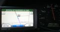
Need to power back a notch - 11 Knots hot, 80 feet to run
55 MPH max

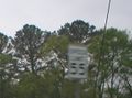
Stephen wondering what's up - Looking south
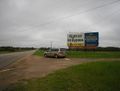
Looking north toward Enterprise, Alabama
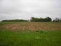
Farm to east
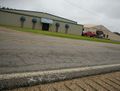
xkcd left as notice to other hashers - Looking west toward awning factory
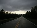
Gray, nasty weather
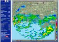
Heavy rain over northwest Florida
Highest point in Florida - Elevation 345 feet


