2009-04-05 48 -122
| Sun 5 Apr 2009 in Bellingham, WA: 48.9456290, -122.4622726 geohashing.info google osm bing/os kml crox |
There's too much snow in the Vancouver mountains to have a hope of getting to the Vancouver geohash, and I haven't got my kayak yet, for the offshore Victoria one. It looks like Bellingham is my best bet, smack in the middle of Lynden, by a river that may or may not be a park. Probably not.
Planning
I intend to do this the lazy way and take the Expo Line and the #502 bus to Aldergrove, then bike across the border and seek access to the geohash site, arriving at approximately 2 p.m. There's a bus home from 264th and Fraser Way at 20 minutes past every hour until late.
Participants
Just Robyn and her inanimate entourage.
Expedition
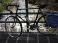
I loaded up the bike with T-Rex, water, GPS, compass, passport and emergency supplies then set off for the Skytrain station. I made good time and was on the correct eastbound train before 11 am, in time to load onto the 502 Langley bus at 11:30. I unloaded at Langley Centre, reconfigured the bicycle and set off for the geohash.
The weather was perfect, about 18 degrees, slight headwind, light traffic. Someone must have flattened out the hills in Highway 1A because it was a breeze getting to Aldergrove, where I turned down Highway 13 to reach the border. Bicycles are pedestrians not vehicles at the US/Canada border, so I leaned the bike against a planter and went in with my passport. I answered the "Why are you going to Lynden?" question with "It's a nice place to bike to," which is true, especially in comparison to Mount Jimmy Jimmy and the waters a hundred metres off the east shore of Galiano Island, the two nearer geohashes for today. He took my passport off to the back to type on computers, no doubt scrutinizing all the other three hour cross border trips I've made in the last year, to see if they coincide with major drug shipments. Apparently drug runners don't geohash because I passed. He told me to bring my bike right through the corridor in front of the desk, to get into the US, so I went outside and brought it through.
The roads immediately get quieter after crossing the border. Vancouver is a big city and its population has spread down to the border along 49th parallel and stopped. There is no large American city pushing northward across the border, just little Lynden eight kilometres south of the line.
I ride south on Guide-Meridian way, past H Street Road. Not H Street or H Road, but H Street Road. I know exactly why it's called that, because I've ridden on it before. In Blaine, the border town at the coast, H Street extends eastwards. if you keep riding on H Street you leave Blaine, and hence you are no longer on the city street, just some road. Which road? The road that gets you to H Street. Hence H Street Road. It's named after a famous letter instead of a general or a civic hero because that's something Americans do. I guess later they can name it after someone.
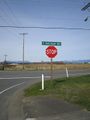
My next interesting street is E. Badger Road. I pull over on East Badger Road and sing the Badger Badger Badger song, complete with actions like arm waving knee bends, crouching mushrooms and slithering (okay more like rolling) snake on the grass. I think that should be a geohashing requirement for anyone on streets named after badgers, mushrooms or snakes.
I turn off Badger Road and almost exactly a kilometre from the geohash is an airport, with the cutest airport fence you ever saw. It looks like something your grandma would put up for decoration, next to a wrought iron bicycle with flower pots on the seat and handebars. I took a picture of a little airplane taking off.
This brought me right to Main Street where Main Place continued straight towards the geohash. I rode down Main Place, but got only to 79 m before it curved away and then ended in a cul-de-sac. All the houses had fences behind them and there was no right-of-way trail down to the river. I kind of expected that, and the geohash was on the other side of the river anyway.
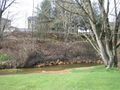
Next I found a pedestrian trail with a bridge leading over the river. At that point I was 140 m away, with the geohash almost directly downriver, in the direction the picture is taken. There was no trail by the river, so I continued over the bridge to the street on the other side, looking for access.
A side street ran next to a newly completed unfurnished house, but it ended 60 m from the geohash. I could see from its unlandscaped yard that there was another level of lawn down below and that that was where the geohash lay. There wasn't access to the lawn from here, but I could see that it appeared to join up with the back lawn of a house further down the block, and that house had two women in dresses dancing on the roof. A very hopeful sign. People who do silly things are more likely to tolerate further silly things.
I rode down to that house and opened with "is that your lawn down below by the river?" Yes it was. "May I go down there to take some pictures please?" Yes I may. I thank them, put the bike against a tree, and head down. It's soon evident that the lower level of lawn belongs to multiple houses, not just the one where I asked, but I continue along to the spot, pretending to take lots of pictures of the river, in case anyone is watching. I get within 2 m with 4 m accuracy and walk around in circles for a bit, trying to look like someone who is lining up the perfect shot. I snap a couple of pictures of the GPS, plus a few real pictures of the river, and head back up. There's another property owner standing there watching me.
"Hello," I say. "Those people said I could come down here to take pictures. I thought this side might be yours, but I was guessing that you were as nice as your neighbours." He was. I asked him where I could get lunch around here but he explained that people didn't work in this town on Sundays and everything was closed.
And he was right. I couldn't even buy a postcard. The Museum had an Open sign, but after I had locked my bike up I discovered that it was closed too, someone had just forgotten to turn out the "Open" neon sign. I rode around town a bit more. Pretty, but very closed.
On the way north the Canada Customs agent asked me if I had bought anything and I told her no, Lynden didn't want to sell me anything on a Sunday. She laughed and agreed, "They're in the Bible Belt there."
Late lunch at Tim Hortons in Canada and then back on transit to get back through the less pleasant parts of town and across the river. Total 55.9 km cycling, the rest on transit.
Photographs
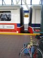
My bicycle Успех and my hashscot T-Rex waiting for the train.
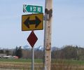
I liked that the same thoroughfare had street and road in its name.
And seeing this road name ...
... I had to do the Badger, Mushroom, Snake dance.
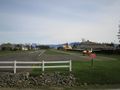
Cuute airport.
The geohash is just down that river.
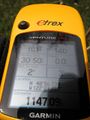
And of course I got there,
right next to the river.
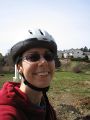
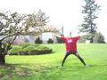
And here I am overlooking the geohash.


Gratuitous Ribbon
Robyn earned the Badger Mushroom Snake Ribbon
|