2009-04-11 48 13
| Sat 11 Apr 2009 in 48,13: 48.5143502, 13.6418935 geohashing.info google osm bing/os kml crox |
In a forest above Vichtenstein, about 20km southeast of Passau.
dawidi with Tomcat and Hans
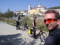
dawidi: We met at 10:30 near the Regensburg-Prüfening train station and got on a regional train that took us and our bikes all the way to Passau, where we arrived shortly before 13:00. We were greeted by awesomely sunny weather, and a comfortable temperature - maybe just a bit too warm in the sun, but nicely cool in the shadows.
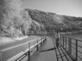
After participating in heavy traffic for a few minutes, we found ourselves on the cycleway on the southern bank of the Inn (just before it flows into the Danube) and followed it downstream. Initially the way was rather narrow and next to an abandoned railroad track; then from the (barely noticeable) Austrian border onwards, it became wider and paved, running next to a federal road.
About 15km downstream from Passau, we stopped to look for a geocache, but didn't find it - the coordinates were pointing 3-5m off a steep slope into the river.
Another kilometer or so later, in a village by the name of Kasten ("Box") we turned right and ascended into the hills on a serpentinuous road. the view into the valley becoming more gorgeous every time we stopped to look. Altogether, we climbed about 350 elevation meters, but since the ascent was partially in cool forest, it was not as exhausting as it could have been. We passed through the village of Vichtenstein, then uphill into another forest where our route leveled off. Lacking GPS topo maps of Austria, we navigated the final two kilometers to the hash using a Google Earth printout and rather sketchy Openstreetmap data on my GPS (which, however, did help avoiding early turns several times until it ran out of roads).
The last 50 meters we had to walk through dry scrub into a clearance where all the trees had been cut down and their roots overturned. We drifted around for a while, proclaiming to have found the exact spot several times before out GPSes agreed on a compromise. A little, dried-up, stream "valley" started just at that spot and went southward from there. Nothing spectacular about the location otherwise. We took some pictures and hit the road again shortly before 16:00.
On the chilly ride downhill, we stopped a couple of times to take more pictures. Back in the Danube valley, we started looking for a place to eat - we hadn't had lunch yet. After passing by two uninviting restaurants and cycling about half the way back to Passau, Tomcat noticed his front tyre was losing pressure, so we pushed on, hoping to get to a gas station (our bikes use car valves and we didn't have a pump). However, we soon arrived at a rather nice looking restaurant where we were provided not only with refreshing drinks, escalopes and an omelette, but also a fitting air pump. Tomcat also injected some kind of sealing rubber solution into the tube, but that later turned out to only slow down the escaping air, not stop it altogether. The tyre was flat again by the time we got home. For the record, the puncture was caused by a thorn we might have picked up at the hash; time for tyres with better puncture protection.
Anyway, after a nice lunch/dinner (lunner? dinch?) and with a temporarily well-inflated tyre, we rather quickly made our way back to Passau and got into the train nearly half an hour before it left. We were back in Regensburg-Prüfening (again without changing trains) not too long after 21:00.
Leaving Passau.
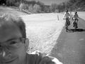
Cycling.
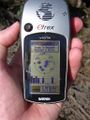
Coordinates reached.
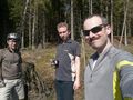
At the hash.

The unavoidable tree marking.
Tomcat and Hans pushing their bikes out of the hash forest.
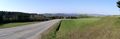
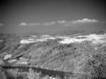
Panoramic view over the Danube valley from above Vichtenstein.
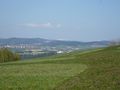
Detail view: snow-covered mountains in the distance.
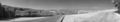
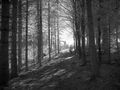
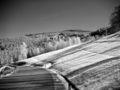
Panoramic view in infrared.
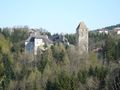
Vichtenstein castle.
Vichtenstein in infrared.
Another infrared view.
And another.
What the...? ;)
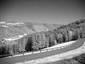
Cycling back along the Danube.
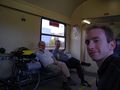
In the train on the way back home.


dawidi, Tomcat and Hans earned the Graticule Unlocked Achievement
|
dawidi, Tomcat and Hans earned the Border geohash achievement
|