2009-04-11 51 7

| Sat 11 Apr 2009 in 51,7: 51.5143502, 7.6418935 geohashing.info google osm bing/os kml crox |
Participants
Plans
I think lyx mentioned some time that there was a hash in Unna. She mentioned a picturessqe river near a sun-drenched piece of bosk, birds chanting, ...
Expedition
..but for most of the day, we did not really find a motivation to go. The sun was shining and we spent the long easter weekend in the garden, reading and playing dart. (Random cat content here) - About half past 7pm, lyx again mentioned that we should go for that expedition. relet dropped his facade of lazyness and was all for it.
Knowing the unreliability of relet's GPS, we scribbled down the coordinates and a rough approach plan on a large sheet of paper, packed two GPS devices and a photo camera, and left. It took a quick drive down the autobahns one and two, and a few more turns after the exit "Unna" to reach the approximate place. The roads were aptly named "Oil lane" and "Water street", and thus easy to remember. Water street was closed for traffic, so we circled around until we found its other end, and a place to park the car.
Thanks to relet's excellent memory, we did not even have to resort to the hand-drawn map yet. Which is a good thing - because thanks to relet's excellent memory, this map still lay on a sideboard in the hallway. With the coordinates.
Well, what we don't have in brains, we have in technology. So we walked in the general direction of the hash, while relet fiddled with his device trying to get to the #geohashing channel to read out the coordinates for today. This, of course, failed (does GPRS use different channels than GSM?), and we resorted to calling home, where lyx' sister would find the sheet of paper and read the coordinates to us.
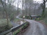
Thus armed with complete knowledge, there was nothing that could fail. Soon, we discovered that the hash lay in a natural reserve - which meant that we should not walk off the beaten path. Hmm, this, and the nearby stream would most probably yield a no trespassing one.
This being the thoughts that crossed our mind, we discovered a path. A path that led right along the stream. In direction of the hash.
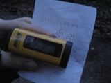
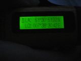
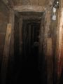
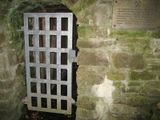
With a bit of fiddling and blundering forth and back along the path, mostly due to the fact that we had to read out coordinates on the m-401 display and compare it with the target - "ok, we have to go further East. No, less east, more north." Etc. - we reached a place that was quite close to the hash. The hash would be right next to it, behind that iron, padlocked gate with the truck and wood stacks.
We thought of ducks. (Technically, no such bird was present)
Now, we weren't actually sure if the hash would not lie - maybe, perhaps, on the other side of the fenced lot. And there was some already trampled, low undergrowth along the fence directly to the left of the gate. So we scrambled along, for a few meters and discovered potatoes. What the duck? This was not a field, and the potatoes were fresh.. is someone feeding the wild boars here? Not that they would require any such support in these lands.
The potatoes almost (but just barely) distracted us from the coordinates. Which were a bit jumpy, but considerably close to the hash. We declared it close enough. And indeed, the satellite shows the stacks of wood, which we had previously ignored, to be directly south of the hash point.
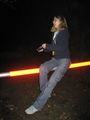
Woo, silly grins and various victory poses followed. Again, the exedition showed us that it's never too late not to give up. And that leaving late means arriving in the dark.
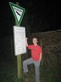
And also, that random areas are always often more interesting than they look on the maps: On the way back, we discovered that we had been on a themed walking trail about the old mining works in the area of Wickede. The nearby shaft was closed, unfortunately. But it had a plaque (translation pending)
Tracklog
maybe?
Photos
inline.
Gallery

in the garden, reading and playing dart

(Random cat content here)
in the general direction of the hash
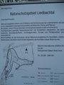
natural reserve
quite close to the hash

that iron, padlocked gate
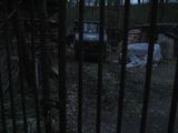
with the truck and wood stacks
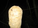
discovered potatoes
considerably close
various
victory poses
about the old mining works
was closed, unfortunately
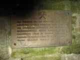
a plaque


