2009-04-13 49 9
| Mon 13 Apr 2009 in Würzburg: 49.0737580, 9.8411838 geohashing.info google osm bing/os kml crox |
Contents
[hide]Location
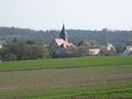
A forest near the little village Herlebach. about 10 km from Schwäbisch Hall.
Expedition by Ekorren
Just another monday morning... well, not really. Actually, here in Germany, like in many other countries, Easter Monday is a public holiday. So it was more of a sunday, anyway, and there were plans for the day. They involved to be at Stuttgart around 14:00. Which isn't very early, so leaving at 12:50 would take me there just in time. And there wasn't any reasonably reachable hashpoint anywhere anyway.
Or was there? After all, my ticket was a daypass for a not at all small region. But there was no hashpoint within of the region I could reach anyway.
Or was there? After all, the coordinates were known since friday, so I had quite some time to go through the "wild phantasizing about going anyway" stage. And finally, a plan emerged from the shadows of impossibility. The daypass would only be valid until a small station named Fornsbach, but a connecting ticket from there to Gaildorf and back from Schwäbisch Hall would be affordable. Bike transport for free. And so, against all reason, I built a cooler pack for the food I'd need in the afternoon to put on the bikes luggage holder, packed everything I would probably need, and set the alarm to 5 o'clock. AM, of course.
At 6:10, I left house for the station, bought the missing tickets, and got on a train to Stuttgart. Changed twice, and around a quarter to nine, got off at Gaildorf. I didn't have any decent map, neither I had any waypoints along a possible route in the GPS. I had a bad printout of the useless crap that google calls maps, also of the even less useful non-car directions their route planner does. I had compared various maps on the net, though, and was quite confident that a specific forest track that leads up into the hills would meet one that leads down again on the other side somewhere, and, no matter where I would hit the other valley, I would find a way from there. So I went for the probably shorter route through the forest instead of the long one along the main road.
Half a minute after leaving the station I got fooled by google maps for the first time. What they called a street along the railway turned out to be more of a service track through a storage of building material. Anyway, there was no gate, I can't even remember any kind of "no trespassing" sign, and it was public holiday, so nobody would care anyway and I went right through it. After a small unintended detour due to another error, I was on reliable roads again and crossed a little old village named Kleinaltdorf, which actually means "little old village". Left the main road to cross Großaltdorf (="large old village") which was a bit larger, and Eutendorf (which has no apparent meaning), then went for the mountains. So far, even google maps wasn't that bad and the track they had recommended was even paved.
Shortly before the nasty slope started, I stopped to check the point and direction again, and a resident jogger came by and asked where I wanted to go. Herlebach. He would recommend another route than shown on the printout. It might be a bit longer but an easier slope. Which, with too much luggage, too much own weight and only seven gears, is usually a good idea. And he might have been right, as the one he showed me was so that I just did not have to get off and push but with reasonable effort got up to the peak. I was now alone in a sleepy forest, and there I met him: The Easter Bunny! He was just sitting on the track, probably thinking about where to hide some more eggs... but as I came near and he spotted me, he ran away. Too bad. I would have appreciated an egg for breakfast.
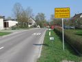
Around 10 I reached the highest point of the outward journey, still far from the hash, and two hours before I wanted to be back at the station. There was a good and almost flat track along the ridge. Actually, this was an old road with some history, as the man at Eutendorf had told me: In former centuries, when salt was a valuable ressource, Schwäbisch Hall was an important producer of salt, and this had been the road along which the salt was shipped in horse-carriages. I followed the historic road northwards and at each intersection tried to guess whether a track would be a good idea to go down. Finally, when there was a sign which said Oberfischach -> I followed this. Oberfischach wouldn't be more than two km of a detour, in worst case, no matter how far to the north I actually was at that time.
So I went downwards into the valley, then up the valley to hash village, and turned into the opposite hills. A few hundred metres from the hash, the way split for one last time, and according to the maps, the right one would lead through the forest and near the hash, while the left one would go around the forest and end about 200 m from the hash. According to my own eyes, the right one was overgrown and hardly passable if walking, while the left one was tarnac. And ended about 200 metres from the hash, google maps was actually right about that. But only before a non-fenced meadow, and such a thing will never even seriously slow down a hasher, will it?
Crossed the meadow, parked the bike on a forest track, and found a way to the hash. 10:50 - coordinates reached. The point itself wasn't very impressing, just in the underwoods near a rather fresh tractor trail. Took proof photo, left marker, left place, and went for the way back.
I was actually running low on time, so I hurried up. The way to Schwäbisch Hall-Hessental is shorter than it had been from Gaildorf, also the side valley I was now is located higher than the valley the train takes (so the ridge wouldn't be so high from this side), and there was a mostly straight minor road, so no more experiments on forest tracks were needed. When reaching the ridge, I was almost good in time again and took a small detour for a short glimpse from a famous viewpoint (see picture), and even found the time to search the nearby geocache. Then I raced back to the road and, downhill with up to 45 km/h, hurried to the station.
Reached the station about 15 minutes before my train left. Damn, shouldn't there be a back entrance somewhere? Can't find it... no time to search. But there's a road tunnel over there...
Reached the station about 10 minutes before my train left, now at the main entrance. Bought a ticket, went to the platform and heaved the bike into the train, and reached Stuttgart half an hour earlier than necessary. Used the time for a detour in a park (actually the very park for which the giant sequoias I found on this hash were ordered) where I met another Easter Bunny. And this time I got to shoot him. Only with the camera, of course :)
Gallery
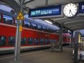
Early start
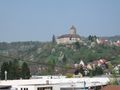
Castle Oppenweiler as seen from the train
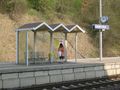
From here by bike
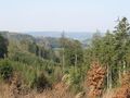
First peak reached - a view back into the valley

It's finally getting spring
Oberfischach
Hash village reached
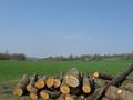
Near hash
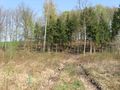
The hashpoint

Hash Flower
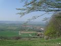
View from the Einkorn

Happy Easter at Stuttgart!
As always, whatever.


Tracklog
... is here.