2009-04-22 49 -122
| Wed 22 Apr 2009 in 49,-122: 49.1746352, -122.6529677 geohashing.info google osm bing/os kml crox |
Contents
Planning & Location
Vancouver's geohash was well out in the water today, possibly obtainable by taking two ferries and a kayak, but that's over five hours worth of ferries and waiting for ferries, plus two hours in a kayak, before even considering the time it would take to bike to and from the ferry, with a kayak on board, and the ferry tolls would total at least $40, probably fifty for all four trips.
One graticule over, the Surrey geohash is on a cul-de-sac in Maple Grove, which I believe is a district of Langley, not a town in itself. Robyn decided to bike the whole 45 km, while Rhonda was forced to take transit, her bicycle being in the shop for a tune up.
Expedition
Robyn
Robyn decided to do this one as a pure bicycle geohash, as opposed to her usual practice of taking transit to get past the mighty Fraser River. Of the four places a car driver could cross the Fraser to get to this geohash, three are permanently or temporarily off limits to bikes. The fourth, which does permit bicycles, is a series of three bridges, the Queensborough, which crosses the north arm of the Fraser, the Annacis Bridge, which goes part way across the south arm to Annacis Island, and the Alex Fraser bridge which finishes the crossing of the Fraser, and leaves you in Delta. Many car drivers are probably unaware that the crossing consists of three separate bridges, because for them the whole experience is a series of freeway ramps leading to the Alex Fraser Bridge. But the cyclist isn't allowed on the freeway ramps, just on the bridge sidewalks, so it's a complicated procedure to get on each bridge via secret connecting sidewalks.
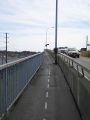
The first access point is the best bicycle bridge ramp I know of anywhere. It is wide enough to use comfortably, well surfaced, beautifully signed, and the best part is that it is is one long straight ramp that starts on a quiet road away from all the bridge traffic, then skips over all the roads and corners and cars and doesn't require you do go down to street level and then climb again. It doesn't get any better than that. It gets worse.
One you cross that bridge you are no longer in New Westminster. You exit via a ramp with a sharp 180 degree switchback, pretty much unrideable, but the norm around here. At the foot of the exit ramp is a directional sign, obscured by vandalism, and the last bicycle-specific directional sign you'll see before finding the ramp to the Annacis Bridge, five turns away. On the way back, I discovered that it's equally efficient to turn the opposite way that the sign directs, and go along a quieter road with bicycle signals. After making the five turns, you reach the foot of a switchback ramp that gets you on bridge number two. At the end of that bridge, the sidewalk takes you along a narrow path that comes out at bridge entrance ramp. No you don't get to go on the ramp. You have to cross it, follow a narrow track behind some bushes, around an industrial site and finally onto the Alex Fraser Bridge sidewalk. Then all you have to do is avoid the obstacles on the sidewalk and not get blown over by the wind.
I exited the Alex Fraser and followed bike path signs for River Road, via a poorly maintained brick bike path. I didn't think much of River Road, either. Most of the traffic was eighteen-wheelers heading for the port. I turned right up 90th, cut over to 96th, and 96th took me most of the way to the geohash. The only wrinkle was that 96th stops at Highway 1 and magically restarts on the other side, so I had to connect the two parts by going over the highway 15 bridge. I stopped there to talk to some construction workers, who warned me that my dinosaur was trying to escape. I resettled him, got back on 96th, passed the giant tree-pushing-down machine and was soon at the geohash, easily identified by the presence of Rhonda. I knew she'd be there early!
Pictorial story of the bike route
I'm interested in what bike routes in other places are like, so I'm giving way too much detail on mine in exchange.
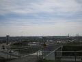
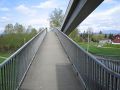
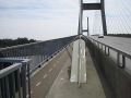
My dream bicycle bridge. The Alex Fraser is at the left edge in the distance.
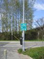
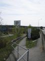
It doesn't matter which way you turn, you'll still get lost.
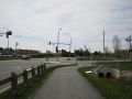
The bicycle lane at the left appeared after I'd committed to the multi-use path.
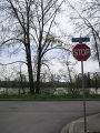
Alex Fraser is ahead, but turn right here, and right again to get to the ...
... access ramp up to the Annacis Bridge.
The bridge is getting closer, but you can't follow this road.
Cross at the crosswalk then turn left, and right behind the bushes by the dark van.
This path really does lead to the Alex Fraser Bridge.
I'm not sure if the dotted line is to separate lanes, or to follow in poor visibility.
but then it does this.
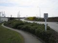
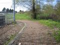
Go left down the hill, not straight along that muddy path (but I ended up on it on the way back)
This wobbly brick bikepath is better than the unpaved one with alternating bands of swamp and bumpy rocks, that I'd be on if I turned the other way leaving the bridge.
You know you're in for a big hill when it has a name. Sixty-two km/h going down. Seven coming back up.


Rhonda
I had a pretty predictable transit expedition. The seabus, skytrain, and bus all left on schedule and connected nicely. Instead of taking the translink-recommended route of waiting 25 minutes for a community shuttle to get the last kilometer, I walked.

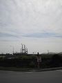
Two blocks from the turn I needed to take, something in the stand of trees at the side of the road caught my eye. I did a double-take and stared - something was waving an entire tree at me! I looked again, and saw nothing unusual, so I kept walking. As I got closer, I saw more tree-tops moving, and then finally saw what sort of machine was capable of picking up trees and waving them around. At the bottom of its grasping hand, there was a large, spinning, circular saw blade. I made a mental note not to cut through this particular empty lot at this time. The sign at the edge of the rapidly-diminishing forest said that there were going to be three lots developed there.
I continued around the corner, taking a second look at the tree-waving machine from the other side, then walked onward, watching my GPS arrow. When it pointed directly sideways, there was, conveniently enough, a street leading in that direction. So far, Google Maps and my GPS were agreeing.
I walked past a man doing some yard work in his front yard, and my GPS counted down below 10m... and then started counting back up again. Oh right, the arrow was pointing sideways again, to the side of the street that didn't have a sidewalk. I walked around a bit, trying to find what my GPS thought was the hash point, then took two photos of the GPS, neither of which are legible unless you know what it's supposed to say. The reflection of the camera in the GPS screen turned out fairly crisp however.
The man with the pruning shears and saw stood up and said, "Can I help you?"
"Um, I'm meeting a friend here, but I'm early."
He nodded and applied his cutting implements to the shrub and didn't chase me off.
I wandered around a bit, since I knew Robyn was going to show up probably in the next fifteen minutes or so. I tried to pat the kitty that was playing jungle in the shrubbery, but while it came up to sniff my hand thoroughly, it wouldn't let me touch.
Then I saw four bikes turn in at the end of the road; a group of three that meandered on and off the sidewalk, and a single racing style bicycle that headed directly down the street.
Both
Rhonda's GPS was uncertain where the geohash was, but Robyn's was quite confident that it was on the gravel just behind the hash markings shown. After the basic documentation of location, markings, and participants was complete, we pondered what game to play. Twister and Charades don't work with only two people and it was a little windy for anything with cards or game pieces. Rhonda regretted not bringing a kite, and she had already chatted with the hedge-trimming cat-owner, so that was accomplished. What to do?
Putting away the geohash marking chalk, Robyn realized that she hadn't put two new pieces in her geohashing kit this morning for nothing. "We're going to play hopscotch!"
It took both of us mining the depth of our brains for grade four memories on how to construct a court and play the game, but we think we produced a passable variation on the game. We started with coins for markers, but the wind kept catching and rolling them, making it pretty tough to get past three, so we switched to bits of bark mulch and the throwing went better. One car came by (the traditional cries of "Car" and "Game On!" ensured our safety) but no one stopped to ask why two grown women were playing hopscotch in the road.
We discussed having some food, but you can't do everything at one geohash.
Return
We walked together the kilometer to Rhonda's bus stop, then Rhonda waited and Robyn headed off on her bike.
Robyn
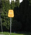
On the way home Robyn came down Nordel Way and there was a sign indicating where cyclists should exit for the different municipalities. She was impressed, until she realized that her "exit" had been one of those tiny sidewalk switchbacks, blocked off with concrete barricades and labelled "Sidewalk Closed." She managed to reintercept the bike route using the muddy path mentioned in the outgoing trip.
Rhonda
The bus system got me home without undue fuss and with only one ticket, and I even managed to get to the bike shop before it closed to pick up my bike.
Gallery
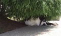
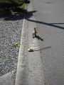
Kitty!
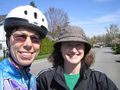
Proof that the two of us were at the geohash together.
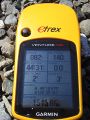
Obligatory proof of location
Markings for any latecomers to find.
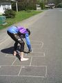
Game preparation
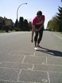
Robyn's throw
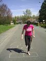
Robyn's turn
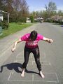
Precise landing as always!
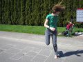
Rhonda turning around to come back to the start


