2009-05-02 48 12
| Sat 2 May 2009 in Landshut, Germany: 48.9585510, 12.0748822 geohashing.info google osm bing/os kml crox |
Between Hohengebraching and Niedergebraching, a couple of kilometers south of Regensburg. 20m into a field, according to Google Earth.
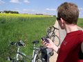
dawidi with a drag-along
Just before leaving to meet my drag-along (a former fellow student) to cycle to the hash (or at least to the road next to it), I reviewed the waypoint on my GPS against an Openstreetmap/Topo map and found it to be *on* the road as it was mapped there, not 20m north of the road as Google Earth and Google maps (both in Map and in Satellite view), had indicated. So maybe this would turn out as a successful expedition after all?
We cycled south through residential areas and then a couple of villages and found our way to the hash without problems. As we approached, my tracklog exactly matched the OSM road, and indeed, parking our bikes on the northern side of the road, we were *on* the spot already - the GPS even went down to 0m distance and stayed there for a while. I was excited enough to forget to take a picture of the satellite page, so you'll have to take my word for that the point I was navigating to was indeed the hashpoint...
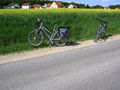
We stood next to the blooming rapeseed field for a couple of minutes, then continued our little afternoon cycling trip and on the way back found two geocaches, both quite nice, larger boxes in interesting locations - one was even in a small cave in a narrow ravine. I had been to that ravine as a child, but couldn't remember where it was or how to get there; now I know again :)
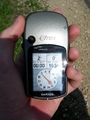
Coordinates reached! Take that, Google.
Happy hasher and two bikes.
I had company.
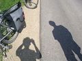
Obligatory mark on the street.
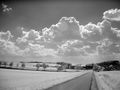
View to the southwest. (IR)
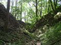
The ravine on the way back.


dawidi earned the Drag-along achievement
|