2009-05-10 48 11
| Sun 10 May 2009 in München, Germany: 48.9003955, 11.8551485 geohashing.info google osm bing/os kml crox |
In the forest just south of the Donaudurchbruch near Kelheim.
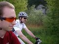
dawidi with Tomcat
We met at the ferry in Großprüfening shortly after 10:00 and cycled up to Bad Abbach where we found a new cache in a gravel pit (but were beat to the FTF by another cacher who went there an hour earlier). Then onwards through Poikam and along the northern side of the Danube up to Kelheim, where we had lunch in the town center pedestrian zone at the Keltenstüberl. Resuming the ride at 14:00 we went uphill through the forest, and after a bit of a detour we found our way to the coordinates. OSM so far has only half of the forest tracks there, but then, about half the tracks shown on the Garmin topo map are imaginary, so neither one was very helpful.
Satellite reception was not very good, and nothing much of interest in the vicinity of the hash, so we got going rather quickly again. Headed south through the forest and then down through the hills to the east, finding a couple more geocaches along the way; one being a large box next to a small pond, the other a short multi-cache along a nice, but visually unimpressive swamp area.
It was getting rather late, so we skipped an addidional cache along the way back, and only stopped in Bad Abbach for a quick coffee and cake, and a large iced chocolate, respectively. I had meant to do maintenance on one of my caches near Matting, but forgot to bring a new logbook, so we skipped that one as well, arriving in Prüfening around 19:30.
At slightly over 80km (and nearly 90 for Tomcat), that was the longest successful pure bicycle expedition for us so far, although it didn't really feel like it.

Cycling there (near Oberndorf).
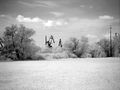
Raptors!? ... no, just industrial cranes or something.
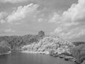
Befreiungshalle ("Hall of Liberation") above Kelheim.
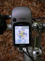
Coordinates reached...

... also with a new Oregon GPS that can take screenshots of itself.
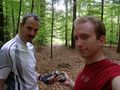
Tomcat and dawidi at the hash.

Shiny trade item in a cache on the way back.
Cycling back (near Matting).


