2009-05-16 45 -122
| Sat 16 May 2009 in Portland, Oregon: 45.3770048, -122.7785416 geohashing.info google osm bing/os kml crox |
Location
A commercial filling station near Tigard, Oregon.
Participants
Plans
Jhon was the first to realize that the hashpoint was looking pretty accessible. Jim noticed a little while later.
There was no planning, other than the fact that Jim planned his long loop of errands from the Farmer's Market to a delivery and a visit to a computer store in Portland to end with a loop through Tualatin at about 4PM.
Jhon planned as well, but Jim wasn't party to the planning or execution.
Expedition
Jim was the first one there. We might qualify for a Fire Geohash Ribbon, since the local Fire department was just leaving with their engine when Jim arrived. Jim hunted around and found the hash point in the middle of the pavement. He was attempting to take pictures of the GPS unit with his cell phone when another car arrived. Someone got out of it, and was asked "Are you from the internet?" When the answer was affirmative, we had achieved the first recorded meetup in this graticule in quite a while. Luckily, Jhon had a reasonable camera and Jim had a GPS unit, so the documentation was easier.
We took pictures of the GPS unit and of us holding the GPS unit.
We were about to leave when we realized that there were many velociraptors hiding under the surface of the land. Luckily, since it was a keycard gas and diesel dispensing station, they were safely stored in tanks underground. (TV Fire and Rescue was getting fuel for their tanker when Jim arrived.)
Achievements
The following were achieved by both Jhon and Jim:
Jhon and Jim earned the Land geohash achievement
|
Jim earned the Two to the N achievement
|
Gallery
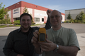
The Culprits! Dun dun dun!
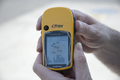
Mmm... Proofalicious
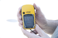
Taking more pictures different screens on Jim's GPS
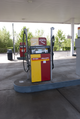
These liquid velociraptors spent a good while stalking us before we noticed them. Kinda freaky...


Photos
Camera raws are available at Jhon's website