2009-05-16 49 -121
| Sat 16 May 2009 in Chilliwack, British Columbia: 49.3770048, -121.7785416 geohashing.info google osm bing/os kml crox |
Location
The hashpoint was on the edge of Harrison Lake, right against the inaccessible shoreline of a peninsula on the southeast shore.
Participants
- Robyn was here.
Planning
Robyn and Wade were already planning a weekend camping trip to the Sasquatch Provincial Park, about seven kilometres from the geohash, so it wasn't too much of a stretch for Robyn to try this one during the camping trip. The Google Maps view showed it on the land portion of the peninsula, while the satellite view shows it in the water. The lake has slight variations with the ocean tides, and seasonal variations, but they aren't that great. If the point were somewhere that was sometimes on land and sometimes in water, it would have to be on a gently sloping beach.
Expedition
The boat launch ramp at Sasquatch Provincial Park was the nearest land-accessible point to the geohash. (The road that runs up the east side of the lake doesn't have water access, because it is up a cliff and behind private property).
One plan was for me to tow Wade to the geohash with my kayak in a smaller inflatable boat (the one used for the English Bay sunrise geohash), but the launch point was 4.5 km from the geohash, and that was a little far for a tow. Wade helped me launch the kayak, and looked after my gear while I paddled out.
It was the easiest kayak geohash so far, with almost no waves or wind. I had to watch out for motorboats, as it was quite a busy lake, but none came near enough to risk collision, and the wakes were smaller than the smallest ocean waves this kayak has already enjoyed. I knew that the geohash was just on the far side of the peninsula, but from the water I couldn't tell exactly where it would be. I was guessing that it was near or just past the knob of land I could see on the end, but it turned out to be just inside it, in a slightly protected cove.
I reached the geohash an hour after launch, despite trying to slow down as I saw how early I would be. I didn't mind having to kill an hour at the geohash though, because it was fun paddling around and exploring the cove. The water was clear and towards the end of the cove became shallow enough that I could see numerous sunken logs on the bottom. They might have been either from trees that fell off the cliff above, or logs that escaped log booms being floated down the river by logging companies.
I found a place just a few metres from the geohash where I could go ashore for a few moments and wait for four o'clock. Some motorboats went by further out, and one honked, but no one else came to the geohash. A shame, as it was a lovely place. I considered geoflashing, but getting fully undressed in a kayak seemed difficult.
After four I paddled back to the boat launch, covering the 4.5 km in only 50 minutes. Wade was there on the beach to marshal me in. As I went to put on my shoes, there was a little red frog on the beach. A frog on a beach! So strange. This was my first fresh water kayak expedition. You never see frogs in salt water.
Photo Gallery
The camera died at the geohash, so I don't have any of the launching area, as I was going to take them on the way back. And I changed the battery right before I left, too.
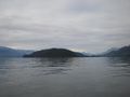
Paddling towards the left edge of the peninsula
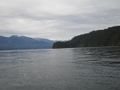
It's going to be close to the tip
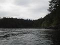
But not quite in this cove
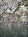
Right by this cliff

And these rocks
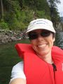
Here I am
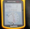
And I'm here at 4 p.m.


Robyn earned the Salt and Pepper Achievement
|