2009-05-21 47 11
| Thu 21 May 2009 in Innsbruck, Austria: 47.4042194, 11.6254432 geohashing.info google osm bing/os kml crox |
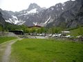
At around 1270m above sea level, in the mouth of a ravine in an alpine valley near Pertisau, southwest of the Achensee in Tyrol. Reached at around 14:00 by dawidi from 49 12.
Planning phase
The coordinates for Geohashing Day were pretty crappy at first glance - in 49 12 and all nearby graticules, the coordinates were far away from me, and in fields or other boring locations. And the only interesting one in 47 11 seemed inaccessible at first glance: high in the alps, on a desolate, rocky slope in a rather remote valley. But it was intriguing... and then, panning around the satellite imagery a bit, I saw colorful, open sunshades at a rather large building not far from the hash - and a long row of parked cars, even large buses... maybe not such a remote place after all? What about train connections?
Further investigation showed that the building was the Gramai-Alm, a full-fledged restaurant/hotel at 1267m up in the valley. The nearest train station was Jenbach, reachable from Regensburg with a reasonable connection via Munich and Rosenheim. However, the last connection that would get me home the same day was very bad, and would require the whole expedition to take just under 4 hours. No way.
In the evening, I tried some other possibilities, and came up with a couple of good connections from Tegernsee, which would allow me to take 10 hours for the expedition, but also required me to cycle an extra 40-50km and cross the Achenpass (elevation 941m). That seemed feasible, although the first climb on the elevation profile seemed scary - from 550m at Jenbach to 950m next to the lake - and I wasn't sure how much of the overpass would have a separate cycle lane. Randomly surfing a couple of tourism websites for the area, I found solutions for both: between Jenbach and the lake, there's a freaking steam rack train line, and all the way to Tegernsee, a new signposted cycle route had been opened in 2004.
Expedition
I got up at 4:00, left home at 6:15, and arrived at the central station in time for the 6:43 train to Munich. On the train, I chatted with another cyclist and casually explained geohashing to him, as it turned out he had tried geocaching a while ago. In Munich, I went to the ticket office to get tickets for the Austrian part of the ride. The ticket for myself was easy, but the teller had no experience with international bicycle tickets, and suggested that I buy one from the train conductor before the train crossed the border. However, that part of the ride was a "self-service line", so I neither had someone to buy the ticket from, nor anyone to ask me for it, so my bike had to dodge its fare. Meh.
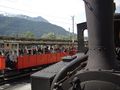
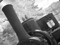
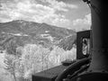
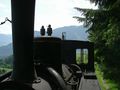
Arriving at Jenbach, I followed a rather large group of international, mostly elderly, tourists to the steam rack train station, and they allowed me on, even though their website explicitly said they'd take bicycles only after registration by phone. The friendly fireman suggested I could stay outside with my bike, at the end of the waggon directly facing the small steam engine that would push the waggons uphill, but warned me it might be a bit hot and loud there. Who could decline a seat (well, a place to stand) with such a good view of the locomotive? I took a lot of photos and video during the ride, and only when I got off the train next to the lake, I realized that my hearing was somewhat funny because of the long exposure to the extremely loud beating sound (which was probably partly from the engine, but mostly the rack rail / cogwheel interface). As I'm writing this, more than 36 hours later, I'm still hearing a high-pitched noise... (update: the noise went away after ~48 hours. whew.)
Anyway... after all the other tourists had moved onto the ship waiting to take them on a zig-zag course along the lake, I started the individual part of my expedition.
I cycled along the lake to Pertisau, then turned left and entered the rather level end of the hash valley on a good, straight road across rich meadows, then along a nice forest. Partially, the road was even closed to motor vehicles. Gradually, the valley became steeper, and at the first restaurant marking the midway, I rested in the shadow for a few minutes and washed my hands and face at one of the many public fountains before pressing on.
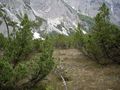
There was a multitude of different routes offered, but not unambiguously signposted, but somehow I chose the right paths, and after crossing the scree-filled dry river bed twice, I found myself on the expected meadow when the GPS indicated the hash to be at 9 o'clock. I pushed my bike across and parked it at the edge of the low brush, and ventured into the side of the valley, across more scree, through a bit of forest with signs of the place being used to graze cows at other times of the year. Across some more brushwood, I could then see into the gorge where the hash should be.
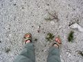
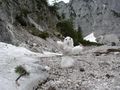
The mouth of the gorge was filled with densely packed scree and sand, unexpectedly easy to walk on. There was a stream emanating from under a heap of leftover snow up in the gorge, and a surprisingly cool wind blowing down from it as well. I jumped over the stream at a suitably narrow point and then did the usual GPS dance and took photos of the spot. I had been to the alps before, but hadn't been to a spot that had as much of an "geology at work, no civilization please" air as this place. I would have liked to stay there longer, but I had a journey ahead and saw darker clouds moving in all of a sudden, so I even forgot to take the usual close-up picture of my GPS.
A few meters up, further into the gorge where the wind was even stronger and colder, I built a small snowman (after getting some snow loose by treating it with a rock) and took pictures of it too, then traced my way back across the stream and back to my bike through the brush, and then with my bike across the meadow to the footpath. From there, lunch was already in sight: a large restaurant "Gramaialm", with buses, lots of cars, American tourists, and cliché-optimized waitresses wielding PDAs. My lunch was rather expensive, but good, and while I ate, it started raining a little but stopped again just when I was about to leave.
For coasting back down the valley, I chose the main road instead of the hiking paths, and on it, passed through a "tongue" of leftover snow several meters tall that made even the car drivers stop for a picture.
Back at the Achensee, I had to return to the train station and go around the northeastern side of the lake, as the (much shorter) trail around the southwest was said to be truly hiking-only, with steps and all. Along the small road next to the lake (as opposed to the motorway going in parallel a few meters further uphill), lots of surfers and divers were just relaxing and drying their neoprene suits in the sun.
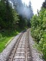
I found myself on the signposted cycleway and followed it through the valley to the border. Partially, the route used residential roads, then suddenly lead into the forest and uphill on a rather ugly track and then back down, for no apparent reason. Other than that, the route was rather boring (compared to the way to the hashpoint, that is). Exactly at the border to Germany, the separate cycleway ended, and the route was signposted on the main road instead. Grudgingly, I complied and inched my way uphill to the Achenpass. One car honked at me, apparently shocked about me taking "their" lane at 10-15kph.
The overpass was marked with an unspectacular sign, and it just went downhill from there - on separate cycleways, although only mostly of reasonable quality. At a ford (which I didn't have to cross), I put my feet into the refreshingly cool and clear water for a bit, then continued, eyeing the clouds. Near Kreuth, a thunderstorm started while I was cycling through a forest. As the rain got stronger, and branches started flying around, I got out my rain cape and chased on up to the next best house, and got myself and my bike under the roof there. The house turned out to be a restaurant, but I ended up just waiting for the rain to stop and not eat dinner there, because the place was already crowded.
After a few more kilometers (which I took very slowly, to avoid picking up unnecessary dirt from the soaking wet roads), I arrived in the town of Tegernsee. Since I had about 50 minutes before the train would leave, I sat down for a hot chocolate in a café next to the lake.
I slept (well, dozed) through most of the train ride back to Regensburg (except for changing trains in Munich), and arrived at home shortly before 1:00 in the morning.
- View the track log of the entire expedition in Google Maps.
- An 8-minute video of my uphill ride on the steam rack train is available on YouTube. I also noticed some interesting factoids on the back of the ticket: the locomotives in use here were built in 1889, so they are 120 years old now; and the train consumes 350kg of coal for each ride (amounting to about 4kg for me and my bike... ouch), as well as 3 cubic meters of water, and the fireman needs to drink 3 liters (of lemonade in this case) due to the heat.

On the train to Munich.
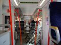
A pile of bikes on the train to Jenbach.
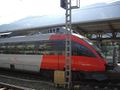
The train that got me to Jenbach.
And now for something different...
...it's a steam locomotive!
Inching its way up into the mountains
... and higher...
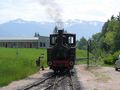
The locomotive uncoupled and switched to the front for the second half of the ride.
Almost level tracks, no need for the rack rail here.
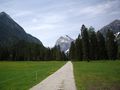
Cycling into the hash valley with Pertisau and the lake behind me.
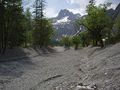
Sand and rocks in this riverbed, no water.
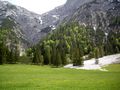
View from the footpath; the hash is behind the trees.
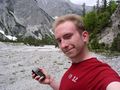
Yay, coordinates reached!
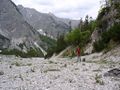
Truly epic location for a hash.


The ground was unexpectedly compact, and easy to walk on.
It's a snowman! In late May!
Low brush on the way back to my bike.
Hmm, not such a lonely valley after all?
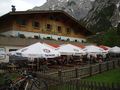
Indeed not.
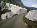
There's really a LOT of snow left.
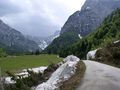
View back into the hash valley before coasting back to the lake.
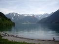
View back south over the lake to Pertisau and the hash.
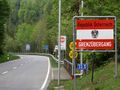
Crossing the border back to Germany.
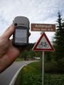
Achenpass. The GPS is probably right - the road is higher than the natural overpass elevation, and I'm holding it up too.
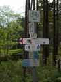
The cycle route was well decorated with signposts.
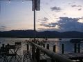
At a boat rental/cafe on the Tegernsee.
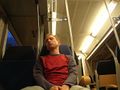
A very tired hasher on the train back to Munich.


dawidi earned the Snowman Geohash Achievement
|
dawidi earned the Border geohash achievement
|
dawidi earned the 2009 Geohashing Day achievement
|